Auel geodata
Auel (Rheinland-Pfalz) is a seat of a fourth-order administrative division; located in Germany in Europe/Berlin (GMT+2) time zone. With population of 233 people, there are 10338 cities with bigger population in this country. Compared to other cities in Germany, 59.7% of cities are located further ↑North; 81.8% of cities are located further →East and 59.1% of cities have lower elevation than Auel. Note1


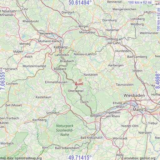
Auel GPS coordinates[2]
50° 10' 0.012" North, 7° 46' 0.012" East
| Map corner | latitude | longitude |
|---|---|---|
| Upper-left | 50.61494°, | 7.06355° |
| Center: | 50.16667°, | 7.76667° |
| Lower-right: | 49.71415°, | 8.4698° |
| Map W x H: | 100.2×100.2 km | = 62.3×62.3mi |
| max Lat: | 55.01917° ⇑59.7% North |
| Auel: | 50.16667° |
| min Lat: | ⇓40.3% South 47.40724° |
| min Long | Auel | max Long |
| 5.92978° | 7.76667° | 14.98853° |
| W 18.2%⇐ | ⇒81.8% E |
Elevation
Elevation of Auel is 284 m = 932 ft, and this is 34.9 m = 115 ft above average elevation for this country.
| Max E: |
1256 m = 4121 ft | 40.9% |
| Auel | 284 m 932 ft | |
| Avg. | 249.1 m = 817 ft | |
Min E: |
-5 m = -16 ft | 59.1% |
See also: Germany elevation on elevation.city.
Geographical zone
Auel is located in North temperate zone (between Tropic of Cancer and the Arctic Circle). Distance of this North polar circle is 1823.2 km =1132.9 mi to North.| Distance of | km | miles | from Auel |
|---|---|---|---|
| North Pole | 4429.1 | 2752.1 | to North |
| Arctic Circle | 1823.2 | 1132.9 | to North |
| Tropic Cancer | 2972.1 | 1846.8 | to South |
| Equator | 5578 | 3466 | to South |


Nearby cities:
15 places around Auel: (largest is in red/bold)
• Bogel
3.5 km =2.2 mi,  42°
42°
• Bornich
4.4 km =2.7 mi,  180°
180°
• Kasdorf
4.6 km =2.9 mi,  15°
15°
• Lautert
4.7 km =2.9 mi,  90°
90°
• Lierschied
1.2 km =0.7 mi,  270°
270°
• Niederwallmenach
3.6 km =2.2 mi, 90°
• Nochern
3.6 km =2.2 mi, 270°
• Oberwallmenach
4.7 km =2.9 mi, 90°
• Patersberg
3 km =1.9 mi,  232°
232°
• Reichenberg
1.9 km =1.2 mi, 180°
• Reitzenhain
2.2 km =1.4 mi,  147°
147°
• Ruppertshofen
4.7 km =2.9 mi, 36°
• Sankt Goar
4.7 km =2.9 mi,  244°
244°
• Sankt Goarshausen
3.9 km =2.4 mi,  256°
256°
• Weyer
4 km =2.5 mi,  297°
297°
Sources, notices
• [Note1] Compared only with cities in Germany existing in our database
• [Src1] Map data: © OpenStreetMap contributors (CC-BY-SA)
• [Src2] Other city data from geonames.org with taken over terms of usage.
• [Src3] Geographical zone / Annual Mean Temperature by Robert A. Rohde @ Wikipedia
