Altendiez geodata
Altendiez (Rheinland-Pfalz) is a seat of a fourth-order administrative division; located in Germany in Europe/Berlin (GMT+2) time zone. With population of 2,332 people, there are 4631 cities with bigger population in this country. Compared to other cities in Germany, 55.4% of cities are located further ↑North; 77.5% of cities are located further →East and 59.6% of cities have higher elevation than Altendiez. Note1


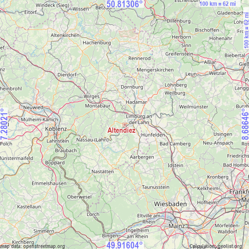
Altendiez GPS coordinates[2]
50° 22' 0.012" North, 7° 58' 59.988" East
| Map corner | latitude | longitude |
|---|---|---|
| Upper-left | 50.81306°, | 7.28021° |
| Center: | 50.36667°, | 7.98333° |
| Lower-right: | 49.91604°, | 8.68646° |
| Map W x H: | 99.7×99.7 km | = 62×62mi |
| max Lat: | 55.01917° ⇑55.4% North |
| Altendiez: | 50.36667° |
| min Lat: | ⇓44.6% South 47.40724° |
| min Long | Altendiez | max Long |
| 5.92978° | 7.98333° | 14.98853° |
| W 22.5%⇐ | ⇒77.5% E |
Elevation
Elevation of Altendiez is 156 m = 512 ft, and this is 93.1 m = 305 ft below average elevation for this country.
| Max E: |
1256 m = 4121 ft | 59.6% |
| Avg. | 249.1 m = 817 ft | |
| Altendiez | 156 m = 512 ft | |
Min E: |
-5 m = -16 ft | 40.4% |
See also: Germany elevation on elevation.city.
Geographical zone
Altendiez is located in North temperate zone (between Tropic of Cancer and the Arctic Circle). Distance of this North polar circle is 1800.9 km =1119 mi to North.| Distance of | km | miles | from Altendiez |
|---|---|---|---|
| North Pole | 4406.8 | 2738.3 | to North |
| Arctic Circle | 1800.9 | 1119 | to North |
| Tropic Cancer | 2994.3 | 1860.6 | to South |
| Equator | 5600.2 | 3479.8 | to South |


Nearby cities:
15 places around Altendiez: (largest is in red/bold)
• Aull
2.5 km =1.6 mi,  32°
32°
• Balduinstein
2.2 km =1.4 mi,  212°
212°
• Birlenbach
1.7 km =1.1 mi,  124°
124°
• Cramberg
4 km =2.5 mi,  226°
226°
• Diez
1.9 km =1.2 mi,  63°
63°
• Flacht
5.3 km =3.3 mi, 116°
• Geilnau
4 km =2.5 mi,  242°
242°
• Gückingen
3.2 km =2 mi, 32°
• Hambach
3.7 km =2.3 mi,  0°
0°
• Heistenbach
1.4 km =0.9 mi,  8°
8°
• Hirschberg
4.4 km =2.7 mi,  287°
287°
• Holzheim
4.8 km =3 mi,  106°
106°
• Langenscheid
2.5 km =1.6 mi, 242°
• Limburg an der Lahn
5.1 km =3.2 mi,  68°
68°
• Steinsberg
4.4 km =2.7 mi, 212°
Sources, notices
• [Note1] Compared only with cities in Germany existing in our database
• [Src1] Map data: © OpenStreetMap contributors (CC-BY-SA)
• [Src2] Other city data from geonames.org with taken over terms of usage.
• [Src3] Geographical zone / Annual Mean Temperature by Robert A. Rohde @ Wikipedia
