Holzheim geodata
Holzheim (Rheinland-Pfalz) is a seat of a fourth-order administrative division; located in Germany in Europe/Berlin (GMT+2) time zone. With population of 913 people, there are 7478 cities with bigger population in this country. Compared to other cities in Germany, 55.5% of cities are located further ↑North; 76.3% of cities are located further →East and 63% of cities have higher elevation than Holzheim. Note1


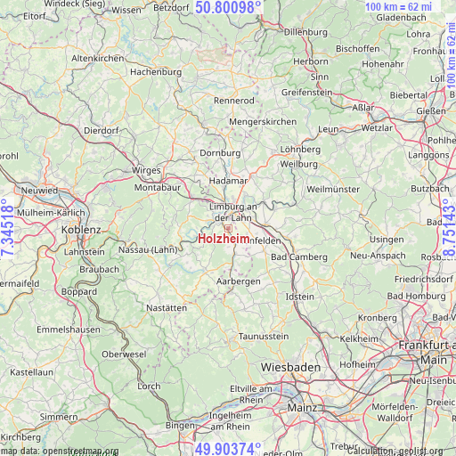
Holzheim GPS coordinates[2]
50° 21' 16.128" North, 8° 2' 53.88" East
| Map corner | latitude | longitude |
|---|---|---|
| Upper-left | 50.80098°, | 7.34518° |
| Center: | 50.35448°, | 8.0483° |
| Lower-right: | 49.90374°, | 8.75143° |
| Map W x H: | 99.8×99.8 km | = 62×62mi |
| max Lat: | 55.01917° ⇑55.5% North |
| Holzheim: | 50.35448° |
| min Lat: | ⇓44.5% South 47.40724° |
| min Long | Holzheim | max Long |
| 5.92978° | 8.0483° | 14.98853° |
| W 23.7%⇐ | ⇒76.3% E |
Elevation
Elevation of Holzheim is 132 m = 433 ft, and this is 117.1 m = 384 ft below average elevation for this country.
| Max E: |
1256 m = 4121 ft | 63% |
| Avg. | 249.1 m = 817 ft | |
| Holzheim | 132 m = 433 ft | |
Min E: |
-5 m = -16 ft | 37% |
See also: Germany elevation on elevation.city.
Geographical zone
Holzheim is located in North temperate zone (between Tropic of Cancer and the Arctic Circle). Distance of this North polar circle is 1802.3 km =1119.9 mi to North.| Distance of | km | miles | from Holzheim |
|---|---|---|---|
| North Pole | 4408.2 | 2739.1 | to North |
| Arctic Circle | 1802.3 | 1119.9 | to North |
| Tropic Cancer | 2993 | 1859.8 | to South |
| Equator | 5598.9 | 3479 | to South |


Nearby cities:
15 places around Holzheim: (largest is in red/bold)
• Altendiez
4.8 km =3 mi,  286°
286°
• Aull
4.8 km =3 mi,  316°
316°
• Balduinstein
5.8 km =3.6 mi,  265°
265°
• Birlenbach
3.3 km =2.1 mi,  277°
277°
• Diez
3.6 km =2.2 mi,  307°
307°
• Flacht
1 km =0.6 mi,  172°
172°
• Gückingen
5 km =3.1 mi, 324°
• Hahnstätten
6.2 km =3.9 mi, 167°
• Hambach
6.8 km =4.2 mi, 317°
• Heistenbach
5.2 km =3.2 mi,  302°
302°
• Limburg an der Lahn
3.2 km =2 mi,  2°
2°
• Lohrheim
4.2 km =2.6 mi,  178°
178°
• Netzbach
5.6 km =3.5 mi,  138°
138°
• Niederneisen
2.4 km =1.5 mi, 177°
• Oberneisen
3.8 km =2.4 mi,  147°
147°
Sources, notices
• [Note1] Compared only with cities in Germany existing in our database
• [Src1] Map data: © OpenStreetMap contributors (CC-BY-SA)
• [Src2] Other city data from geonames.org with taken over terms of usage.
• [Src3] Geographical zone / Annual Mean Temperature by Robert A. Rohde @ Wikipedia
