Alperstedt geodata
Alperstedt (Thuringia) is a seat of a fourth-order administrative division; located in Germany in Europe/Berlin (GMT+2) time zone. With population of 743 people, there are 8136 cities with bigger population in this country. Compared to other cities in Germany, 59.7% of cities are located further ↓South; 67.6% of cities are located further ←West and 58.9% of cities have higher elevation than Alperstedt. Note1


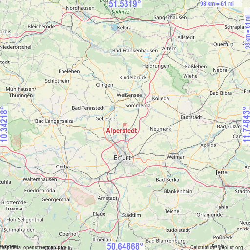
Alperstedt GPS coordinates[2]
51° 5' 32.64" North, 11° 2' 43.08" East
| Map corner | latitude | longitude |
|---|---|---|
| Upper-left | 51.5319°, | 10.34218° |
| Center: | 51.0924°, | 11.0453° |
| Lower-right: | 50.64868°, | 11.74843° |
| Map W x H: | 98.2×98.2 km | = 61×61mi |
| max Lat: | 55.01917° ⇑40.3% North |
| Alperstedt: | 51.0924° |
| min Lat: | ⇓59.7% South 47.40724° |
| min Long | Alperstedt | max Long |
| 5.92978° | 11.0453° | 14.98853° |
| W 67.6%⇐ | ⇒32.4% E |
Elevation
Elevation of Alperstedt is 161 m = 528 ft, and this is 88.1 m = 289 ft below average elevation for this country.
| Max E: |
1256 m = 4121 ft | 58.9% |
| Avg. | 249.1 m = 817 ft | |
| Alperstedt | 161 m = 528 ft | |
Min E: |
-5 m = -16 ft | 41.1% |
See also: Germany elevation on elevation.city.
Geographical zone
Alperstedt is located in North temperate zone (between Tropic of Cancer and the Arctic Circle). Distance of this North polar circle is 1720.2 km =1068.9 mi to North.| Distance of | km | miles | from Alperstedt |
|---|---|---|---|
| North Pole | 4326.1 | 2688.1 | to North |
| Arctic Circle | 1720.2 | 1068.9 | to North |
| Tropic Cancer | 3075 | 1910.7 | to South |
| Equator | 5680.9 | 3529.9 | to South |


Nearby cities:
15 places around Alperstedt: (largest is in red/bold)
• Eckstedt
7.4 km =4.6 mi,  108°
108°
• Elxleben
8.2 km =5.1 mi,  234°
234°
• Gebesee
8.1 km =5 mi,  287°
287°
• Großrudestedt
3.8 km =2.4 mi,  88°
88°
• Haßleben
3.9 km =2.4 mi,  298°
298°
• Henschleben
7.1 km =4.4 mi,  309°
309°
• Kleinmölsen
8.2 km =5.1 mi,  142°
142°
• Nöda
3.5 km =2.2 mi,  214°
214°
• Riethnordhausen
3.3 km =2.1 mi,  252°
252°
• Ringleben
6.7 km =4.2 mi,  277°
277°
• Schloßvippach
7.1 km =4.4 mi,  78°
78°
• Udestedt
7.7 km =4.8 mi,  127°
127°
• Walschleben
8.3 km =5.2 mi, 249°
• Werningshausen
6.1 km =3.8 mi,  329°
329°
• Wundersleben
6.9 km =4.3 mi,  356°
356°
Sources, notices
• [Note1] Compared only with cities in Germany existing in our database
• [Src1] Map data: © OpenStreetMap contributors (CC-BY-SA)
• [Src2] Other city data from geonames.org with taken over terms of usage.
• [Src3] Geographical zone / Annual Mean Temperature by Robert A. Rohde @ Wikipedia
