Albershausen geodata
Albershausen (Baden-Württemberg) is a seat of a fourth-order administrative division; located in Germany in Europe/Berlin (GMT+2) time zone. With population of 4,286 people, there are 3140 cities with bigger population in this country. Compared to other cities in Germany, 86.6% of cities are located further ↑North; 56.8% of cities are located further →East and 64.5% of cities have lower elevation than Albershausen. Note1
Administrative division(s):
- Level 1: Baden-Württemberg
- Level 2: Regierungsbezirk Stuttgart
- Level 3: Landkreis Göppingen
- Level 4: Albershausen


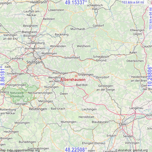
Albershausen GPS coordinates[2]
48° 41' 28.896" North, 9° 33' 53.748" East
| Map corner | latitude | longitude |
|---|---|---|
| Upper-left | 49.15337°, | 8.86181° |
| Center: | 48.69136°, | 9.56493° |
| Lower-right: | 48.22508°, | 10.26806° |
| Map W x H: | 103.2×103.2 km | = 64.1×64.1mi |
| max Lat: | 55.01917° ⇑86.6% North |
| Albershausen: | 48.69136° |
| min Lat: | ⇓13.4% South 47.40724° |
| min Long | Albershausen | max Long |
| 5.92978° | 9.56493° | 14.98853° |
| W 43.2%⇐ | ⇒56.8% E |
Elevation
Elevation of Albershausen is 318 m = 1043 ft, and this is 68.9 m = 226 ft above average elevation for this country.
| Max E: |
1256 m = 4121 ft | 35.5% |
| Albershausen | 318 m 1043 ft | |
| Avg. | 249.1 m = 817 ft | |
Min E: |
-5 m = -16 ft | 64.5% |
See also: Germany elevation on elevation.city.
Geographical zone
Albershausen is located in North temperate zone (between Tropic of Cancer and the Arctic Circle). Distance of this North polar circle is 1987.2 km =1234.8 mi to North.| Distance of | km | miles | from Albershausen |
|---|---|---|---|
| North Pole | 4593.1 | 2854 | to North |
| Arctic Circle | 1987.2 | 1234.8 | to North |
| Tropic Cancer | 2808.1 | 1744.9 | to South |
| Equator | 5414 | 3364.1 | to South |


Nearby cities:
15 places around Albershausen: (largest is in red/bold)
• Aichelberg
6.2 km =3.9 mi,  180°
180°
• Boll
6.4 km =4 mi,  146°
146°
• Dürnau
7.6 km =4.7 mi,  137°
137°
• Ebersbach an der Fils
4.1 km =2.5 mi,  312°
312°
• Göppingen
6.5 km =4 mi,  78°
78°
• Hattenhofen
2.9 km =1.8 mi,  165°
165°
• Heiningen
7 km =4.3 mi,  117°
117°
• Hochdorf
7.3 km =4.5 mi,  271°
271°
• Holzmaden
7.4 km =4.6 mi,  208°
208°
• Ohmden
5.8 km =3.6 mi, 208°
• Rechberghausen
7.3 km =4.5 mi,  52°
52°
• Schlierbach
4 km =2.5 mi,  240°
240°
• Uhingen
2.1 km =1.3 mi, 45°
• Wangen
5.4 km =3.4 mi,  39°
39°
• Zell unter Aichelberg
4.8 km =3 mi, 174°
Sources, notices
• [Note1] Compared only with cities in Germany existing in our database
• [Src1] Map data: © OpenStreetMap contributors (CC-BY-SA)
• [Src2] Other city data from geonames.org with taken over terms of usage.
• [Src3] Geographical zone / Annual Mean Temperature by Robert A. Rohde @ Wikipedia
