Niefern-Öschelbronn geodata
Niefern-Öschelbronn (Baden-Württemberg) is a seat of a fourth-order administrative division; located in Germany in Europe/Berlin (GMT+2) time zone. With population of 12,341 people, there are 1323 cities with bigger population in this country. Compared to other cities in Germany, 83.9% of cities are located further ↑North; 68.2% of cities are located further →East and 52.2% of cities have lower elevation than Niefern-Öschelbronn. Note1
Administrative division(s):
- Level 1: Baden-Württemberg
- Level 2: Karlsruhe Region
- Level 3: Enzkreis
- Level 4: Niefern-Öschelbronn


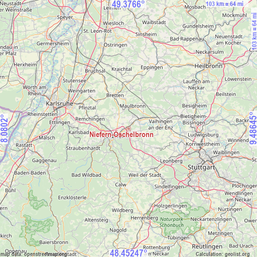
Niefern-Öschelbronn GPS coordinates[2]
48° 55' 0.012" North, 8° 46' 59.988" East
| Map corner | latitude | longitude |
|---|---|---|
| Upper-left | 49.3766°, | 8.0802° |
| Center: | 48.91667°, | 8.78333° |
| Lower-right: | 48.45247°, | 9.48645° |
| Map W x H: | 102.8×102.8 km | = 63.9×63.9mi |
| max Lat: | 55.01917° ⇑83.9% North |
| Niefern-Öschelbronn: | 48.91667° |
| min Lat: | ⇓16.1% South 47.40724° |
| min Long | Niefern-Öschel | max Long |
| 5.92978° | 8.78333° | 14.98853° |
| W 31.8%⇐ | ⇒68.2% E |
Elevation
Elevation of Niefern-Öschelbronn is 241 m = 791 ft, and this is 8.1 m = 27 ft below average elevation for this country.
| Max E: |
1256 m = 4121 ft | 47.8% |
| Avg. | 249.1 m = 817 ft | |
| Niefern-Öschelbronn | 241 m = 791 ft | |
Min E: |
-5 m = -16 ft | 52.2% |
See also: Germany elevation on elevation.city.
Geographical zone
Niefern-Öschelbronn is located in North temperate zone (between Tropic of Cancer and the Arctic Circle). Distance of this North polar circle is 1962.2 km =1219.3 mi to North.| Distance of | km | miles | from Niefern-Öschelbronn |
|---|---|---|---|
| North Pole | 4568 | 2838.4 | to North |
| Arctic Circle | 1962.2 | 1219.3 | to North |
| Tropic Cancer | 2833.1 | 1760.4 | to South |
| Equator | 5439 | 3379.6 | to South |


Nearby cities:
15 places around Niefern-Öschelbronn: (largest is in red/bold)
• Eisingen
9.3 km =5.8 mi,  293°
293°
• Eutingen an der Enz
2.6 km =1.6 mi,  259°
259°
• Friolzheim
10 km =6.2 mi,  158°
158°
• Ispringen
8.5 km =5.3 mi,  270°
270°
• Kieselbronn
3.1 km =1.9 mi,  307°
307°
• Maulbronn
9.3 km =5.8 mi,  9°
9°
• Mönsheim
8.2 km =5.1 mi,  132°
132°
• Mühlacker
5.2 km =3.2 mi,  48°
48°
• Pforzheim
7.1 km =4.4 mi,  239°
239°
• Tiefenbronn
10.4 km =6.5 mi,  172°
172°
• Wiernsheim
6.1 km =3.8 mi, 127°
• Wimsheim
8.3 km =5.2 mi,  153°
153°
• Wurmberg
6.1 km =3.8 mi, 156°
• Ölbronn-Dürrn
6.1 km =3.8 mi,  336°
336°
• Ötisheim
5.7 km =3.5 mi, 12°
Sources, notices
• [Note1] Compared only with cities in Germany existing in our database
• [Src1] Map data: © OpenStreetMap contributors (CC-BY-SA)
• [Src2] Other city data from geonames.org with taken over terms of usage.
• [Src3] Geographical zone / Annual Mean Temperature by Robert A. Rohde @ Wikipedia
