Peterswald-Löffelscheid geodata
Peterswald-Löffelscheid (Rheinland-Pfalz) is a seat of a fourth-order administrative division; located in Germany in Europe/Berlin (GMT+2) time zone. With population of 810 people, there are 7858 cities with bigger population in this country. Compared to other cities in Germany, 63.8% of cities are located further ↑North; 90% of cities are located further →East and 80.8% of cities have lower elevation than Peterswald-Löffelscheid. Note1
Administrative division(s):
- Level 1: Rheinland-Pfalz
- Level 3: Landkreis Cochem-Zell
- Level 4: Peterswald-Löffelscheid
Current local time in Peterswald-Löffelscheid:
03:55 PM, TuesdayDifference from your time zone: hours


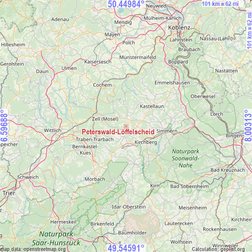
Peterswald-Löffelscheid GPS coordinates[2]
50° 0' 0" North, 7° 18' 0" East
| Map corner | latitude | longitude |
|---|---|---|
| Upper-left | 50.44984°, | 6.59688° |
| Center: | 50°, | 7.3° |
| Lower-right: | 49.54591°, | 8.00313° |
| Map W x H: | 100.5×100.5 km | = 62.4×62.4mi |
| max Lat: | 55.01917° ⇑63.8% North |
| Peterswald-Löffelscheid: | 50° |
| min Lat: | ⇓36.2% South 47.40724° |
| min Long | Peterswald-Löf | max Long |
| 5.92978° | 7.3° | 14.98853° |
| W 10%⇐ | ⇒90% E |
Elevation
Elevation of Peterswald-Löffelscheid is 438 m = 1437 ft, and this is 188.9 m = 620 ft above average elevation for this country.
| Max E: |
1256 m = 4121 ft | 19.2% |
| Peterswald-Löffelscheid | 438 m 1437 ft | |
| Avg. | 249.1 m = 817 ft | |
Min E: |
-5 m = -16 ft | 80.8% |
See also: Germany elevation on elevation.city.
Geographical zone
Peterswald-Löffelscheid is located in North temperate zone (between Tropic of Cancer and the Arctic Circle). Distance of this North polar circle is 1841.7 km =1144.4 mi to North.| Distance of | km | miles | from Peterswald-Löffelscheid |
|---|---|---|---|
| North Pole | 4447.6 | 2763.6 | to North |
| Arctic Circle | 1841.7 | 1144.4 | to North |
| Tropic Cancer | 2953.6 | 1835.3 | to South |
| Equator | 5559.5 | 3454.5 | to South |


Nearby cities:
15 places around Peterswald-Löffelscheid: (largest is in red/bold)
• Altlay
2.4 km =1.5 mi,  235°
235°
• Belg
1.9 km =1.2 mi,  180°
180°
• Blankenrath
4.3 km =2.7 mi,  2°
2°
• Hahn
4.4 km =2.7 mi,  212°
212°
• Haserich
4.4 km =2.7 mi,  32°
32°
• Kappel
4.8 km =3 mi,  90°
90°
• Kludenbach
5.1 km =3.2 mi,  111°
111°
• Panzweiler
1.9 km =1.2 mi, 0°
• Rödelhausen
2.4 km =1.5 mi, 90°
• Schauren
3 km =1.9 mi,  307°
307°
• Schwarzen
4.4 km =2.7 mi,  147°
147°
• Tellig
5.1 km =3.2 mi,  316°
316°
• Todenroth
5.1 km =3.2 mi,  136°
136°
• Walhausen
3.9 km =2.4 mi,  342°
342°
• Würrich
1.9 km =1.2 mi, 180°
Sources, notices
• [Note1] Compared only with cities in Germany existing in our database
• [Src1] Map data: © OpenStreetMap contributors (CC-BY-SA)
• [Src2] Other city data from geonames.org with taken over terms of usage.
• [Src3] Geographical zone / Annual Mean Temperature by Robert A. Rohde @ Wikipedia
