Hørning geodata
Hørning (Central Jutland) is a populated place; located in Denmark in Europe/Copenhagen (GMT+2) time zone. With population of 6,085 people, there are 115 cities with bigger population in this country. Compared to other cities in Denmark, 69% of cities are located further ↓South; 59.1% of cities are located further →East and 95.3% of cities have lower elevation than Hørning. Note1


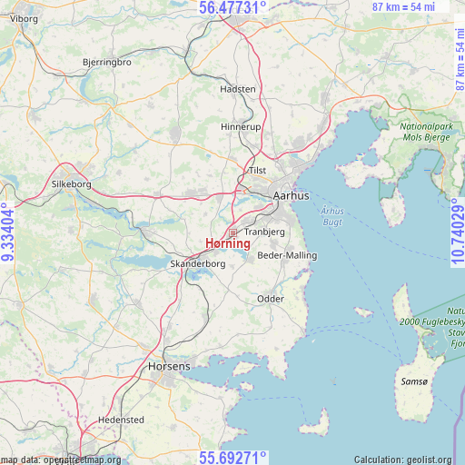
Hørning GPS coordinates[2]
56° 5' 13.236" North, 10° 2' 13.776" East
| Map corner | latitude | longitude |
|---|---|---|
| Upper-left | 56.47731°, | 9.33404° |
| Center: | 56.08701°, | 10.03716° |
| Lower-right: | 55.69271°, | 10.74029° |
| Map W x H: | 87.2×87.2 km | = 54.2×54.2mi |
| max Lat: | 57.72093° ⇑31% North |
| Hørning: | 56.08701° |
| min Lat: | ⇓69% South 54.57644° |
| min Long | Hørning | max Long |
| 8.12605° | 10.03716° | 15.18662° |
| W 40.9%⇐ | ⇒59.1% E |
Elevation
Elevation of Hørning is 68 m = 223 ft, and this is 40.7 m = 134 ft above average elevation for this country.
| Max E: |
114 m = 374 ft | 4.7% |
| Hørning | 68 m 223 ft | |
| Avg. | 27.3 m = 90 ft | |
Min E: |
0 m = 0 ft | 95.3% |
See also: Denmark elevation on elevation.city.
Geographical zone
Hørning is located in North temperate zone (between Tropic of Cancer and the Arctic Circle). Distance of this North polar circle is 1164.9 km =723.8 mi to North.| Distance of | km | miles | from Hørning |
|---|---|---|---|
| North Pole | 3770.8 | 2343.1 | to North |
| Arctic Circle | 1164.9 | 723.8 | to North |
| Tropic Cancer | 3630.4 | 2255.8 | to South |
| Equator | 6236.3 | 3875.1 | to South |


Nearby cities:
15 places around Hørning: (largest is in red/bold)
• Beder
11.2 km =7 mi,  105°
105°
• Framlev
7.9 km =4.9 mi,  349°
349°
• Galten
10.9 km =6.8 mi,  317°
317°
• Kolt
3.1 km =1.9 mi,  40°
40°
• Malling
11.4 km =7.1 mi,  119°
119°
• Mårslet
8 km =5 mi, 106°
• Odder
14.6 km =9.1 mi,  150°
150°
• Sabro
14 km =8.7 mi,  359°
359°
• Skanderborg
8.8 km =5.5 mi,  228°
228°
• Skovby
9.6 km =6 mi, 323°
• Solbjerg
5.8 km =3.6 mi, 148°
• Stavtrup
7.1 km =4.4 mi,  46°
46°
• Stilling
4.1 km =2.5 mi, 227°
• Tranbjerg
6.2 km =3.9 mi,  81°
81°
• Århus
13.3 km =8.3 mi, 54°
Sources, notices
• [Note1] Compared only with cities in Denmark existing in our database
• [Src1] Map data: © OpenStreetMap contributors (CC-BY-SA)
• [Src2] Other city data from geonames.org with taken over terms of usage.
• [Src3] Geographical zone / Annual Mean Temperature by Robert A. Rohde @ Wikipedia
