Villarpando geodata
Villarpando (Azua) is a populated place; located in Dominican Republic in America/Santo_Domingo (GMT-4) time zone. With population of 3,016 people, there are 146 cities with bigger population in this country. Compared to other cities in Dominican Republic, 61.6% of cities are located further ↑North; 68.2% of cities are located further →East and 80.1% of cities have lower elevation than Villarpando. Note1
Administrative division(s):
- Level 1: Azua
- Level 2: Las Yayas De Viajama
- Level 3: Villarpando (D. M.).
- Level 4: Villarpando (Zona Urbana)


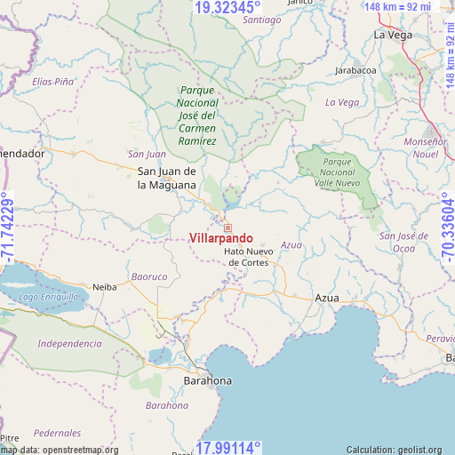
Villarpando GPS coordinates[2]
18° 39' 30.96" North, 71° 2' 20.976" West
| Map corner | latitude | longitude |
|---|---|---|
| Upper-left | 19.32345°, | -71.74229° |
| Center: | 18.6586°, | -71.03916° |
| Lower-right: | 17.99114°, | -70.33604° |
| Map W x H: | 148.1×148.1 km | = 92×92mi |
| max Lat: | 19.89131° ⇑61.6% North |
| Villarpando: | 18.6586° |
| min Lat: | ⇓38.4% South 17.80136° |
| min Long | Villarpando | max Long |
| -71.85022° | -71.03916° | -68.40431° |
| W 31.8%⇐ | ⇒68.2% E |
Elevation
Elevation of Villarpando is 287 m = 942 ft, and this is 120.7 m = 396 ft above average elevation for this country.
| Max E: |
1242 m = 4075 ft | 19.9% |
| Villarpando | 287 m 942 ft | |
| Avg. | 166.3 m = 546 ft | |
Min E: |
5 m = 16 ft | 80.1% |
See also: Dominican Republic elevation on elevation.city.
Geographical zone
Villarpando is located in North Torrid zone (between Equator and Tropic of Cancer). Distance of this Northern Tropic circle is 531.3 km =330.1 mi to North.| Distance of | km | miles | from Villarpando |
|---|---|---|---|
| North Pole | 7932.4 | 4929 | to North |
| Arctic Circle | 5326.5 | 3309.7 | to North |
| Tropic Cancer | 531.3 | 330.1 | to North |
| Equator | 2074.6 | 1289.1 | to South |


Nearby cities:
15 places around Villarpando: (largest is in red/bold)
• Bohechío
14 km =8.7 mi,  22°
22°
• Canoa
36 km =22.4 mi,  200°
200°
• El Guayabal
23.6 km =14.7 mi,  64°
64°
• El Palmar
35.1 km =21.8 mi,  218°
218°
• Galván
36.4 km =22.6 mi,  241°
241°
• Juan de Herrera
31.8 km =19.8 mi,  318°
318°
• Padre Las Casas
13.3 km =8.3 mi,  52°
52°
• Peralta
29.6 km =18.4 mi,  106°
106°
• Sabana Yegua
6.9 km =4.3 mi, 20°
• San Juan de la Maguana
25.9 km =16.1 mi,  309°
309°
• Tamayo
34 km =21.1 mi,  210°
210°
• Tábara Arriba
19.5 km =12.1 mi,  120°
120°
• Vallejuelo
31.1 km =19.3 mi,  268°
268°
• Vicente Noble
33.9 km =21.1 mi, 205°
• Yayas de Viajama
13.1 km =8.1 mi, 115°
Sources, notices
• [Note1] Compared only with cities in Dominican Republic existing in our database
• [Src1] Map data: © OpenStreetMap contributors (CC-BY-SA)
• [Src2] Other city data from geonames.org with taken over terms of usage.
• [Src3] Geographical zone / Annual Mean Temperature by Robert A. Rohde @ Wikipedia
