Polo geodata
Polo (Barahona) is a populated place; located in Dominican Republic in America/Santo_Domingo (GMT-4) time zone. With population of 2,121 people, there are 168 cities with bigger population in this country. Compared to other cities in Dominican Republic, 97.2% of cities are located further ↑North; 82% of cities are located further →East and 96.7% of cities have lower elevation than Polo. Note1


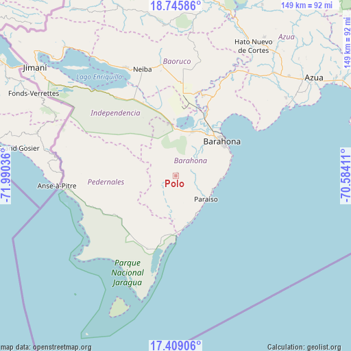
Polo GPS coordinates[2]
18° 4' 43.428" North, 71° 17' 14.028" West
| Map corner | latitude | longitude |
|---|---|---|
| Upper-left | 18.74586°, | -71.99036° |
| Center: | 18.07873°, | -71.28723° |
| Lower-right: | 17.40906°, | -70.58411° |
| Map W x H: | 148.6×148.6 km | = 92.3×92.3mi |
| max Lat: | 19.89131° ⇑97.2% North |
| Polo: | 18.07873° |
| min Lat: | ⇓2.8% South 17.80136° |
| min Long | Polo | max Long |
| -71.85022° | -71.28723° | -68.40431° |
| W 18%⇐ | ⇒82% E |
Elevation
Elevation of Polo is 735 m = 2411 ft, and this is 568.7 m = 1866 ft above average elevation for this country.
| Max E: |
1242 m = 4075 ft | 3.3% |
| Polo | 735 m 2411 ft | |
| Avg. | 166.3 m = 546 ft | |
Min E: |
5 m = 16 ft | 96.7% |
See also: Dominican Republic elevation on elevation.city.
Geographical zone
Polo is located in North Torrid zone (between Equator and Tropic of Cancer). Distance of this Northern Tropic circle is 595.8 km =370.2 mi to North.| Distance of | km | miles | from Polo |
|---|---|---|---|
| North Pole | 7996.9 | 4969 | to North |
| Arctic Circle | 5391 | 3349.8 | to North |
| Tropic Cancer | 595.8 | 370.2 | to North |
| Equator | 2010.2 | 1249.1 | to South |


Nearby cities:
15 places around Polo: (largest is in red/bold)
• Cabral
20.5 km =12.7 mi,  21°
21°
• Cachón
21.5 km =13.4 mi,  28°
28°
• Cristóbal
23.9 km =14.9 mi,  358°
358°
• El Peñón
26.5 km =16.5 mi, 24°
• Enriquillo
20.7 km =12.9 mi,  163°
163°
• Fundación
25.7 km =16 mi, 25°
• Jaquimeyes
29.1 km =18.1 mi, 27°
• Juancho
24.6 km =15.3 mi,  181°
181°
• La Ciénaga
19.1 km =11.9 mi,  93°
93°
• La Uvilla
32.5 km =20.2 mi,  14°
14°
• Las Salinas
22 km =13.7 mi,  352°
352°
• Oviedo
33.1 km =20.6 mi,  201°
201°
• Paraíso
16.1 km =10 mi,  126°
126°
• Pescadería
24.6 km =15.3 mi, 31°
• Santa Cruz de Barahona
24.4 km =15.2 mi,  53°
53°
Sources, notices
• [Note1] Compared only with cities in Dominican Republic existing in our database
• [Src1] Map data: © OpenStreetMap contributors (CC-BY-SA)
• [Src2] Other city data from geonames.org with taken over terms of usage.
• [Src3] Geographical zone / Annual Mean Temperature by Robert A. Rohde @ Wikipedia
