Kostivere geodata
Kostivere (Harjumaa) is a populated place; located in Estonia in Europe/Tallinn (GMT+3) time zone. With population of 790 people, there are 111 cities with bigger population in this country. Compared to other cities in Estonia, 89.5% of cities are located further ↓South; 58.4% of cities are located further →East and 62.1% of cities have higher elevation than Kostivere. Note1


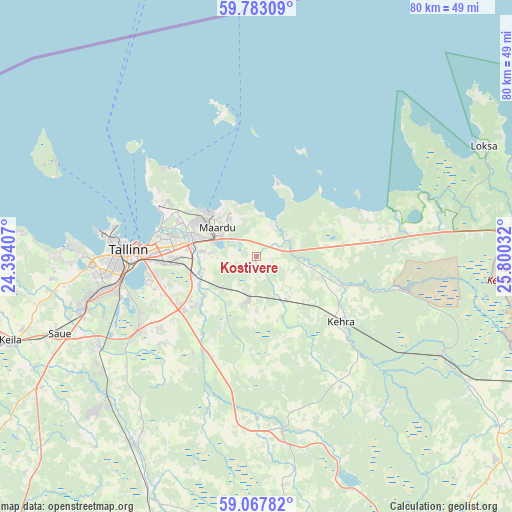
Kostivere GPS coordinates[2]
59° 25' 38.424" North, 25° 5' 49.884" East
| Map corner | latitude | longitude |
|---|---|---|
| Upper-left | 59.78309°, | 24.39407° |
| Center: | 59.42734°, | 25.09719° |
| Lower-right: | 59.06782°, | 25.80032° |
| Map W x H: | 79.5×79.5 km | = 49.4×49.4mi |
| max Lat: | 59.57639° ⇑10.5% North |
| Kostivere: | 59.42734° |
| min Lat: | ⇓89.5% South 57.72778° |
| min Long | Kostivere | max Long |
| 22.24646° | 25.09719° | 28.19028° |
| W 41.6%⇐ | ⇒58.4% E |
Elevation
Elevation of Kostivere is 44 m = 144 ft, and this is 9.2 m = 30 ft below average elevation for this country.
| Max E: |
141 m = 463 ft | 62.1% |
| Avg. | 53.2 m = 175 ft | |
| Kostivere | 44 m = 144 ft | |
Min E: |
6 m = 20 ft | 37.9% |
See also: Estonia elevation on elevation.city.
Geographical zone
Kostivere is located in North temperate zone (between Tropic of Cancer and the Arctic Circle). Distance of this North polar circle is 793.5 km =493.1 mi to North.| Distance of | km | miles | from Kostivere |
|---|---|---|---|
| North Pole | 3399.4 | 2112.3 | to North |
| Arctic Circle | 793.5 | 493.1 | to North |
| Tropic Cancer | 4001.8 | 2486.6 | to South |
| Equator | 6607.7 | 4105.8 | to South |


Nearby cities:
15 places around Kostivere: (largest is in red/bold)
• Aruküla
6.8 km =4.2 mi,  190°
190°
• Jüri
14.1 km =8.8 mi,  234°
234°
• Kehra
16.2 km =10.1 mi,  128°
128°
• Kiiu
16.1 km =10 mi,  81°
81°
• Kose
12.9 km =8 mi,  286°
286°
• Lagedi
9.3 km =5.8 mi,  253°
253°
• Loo
8.4 km =5.2 mi,  272°
272°
• Maardu
7.8 km =4.8 mi,  302°
302°
• Peetri
16.4 km =10.2 mi,  257°
257°
• Raasiku
8.3 km =5.2 mi,  144°
144°
• Randvere
14 km =8.7 mi,  309°
309°
• Vaida
17.1 km =10.6 mi,  203°
203°
• Valkla
13.7 km =8.5 mi,  68°
68°
• Viimsi
15.6 km =9.7 mi, 301°
• Viimsi
16.5 km =10.3 mi, 301°
Sources, notices
• [Note1] Compared only with cities in Estonia existing in our database
• [Src1] Map data: © OpenStreetMap contributors (CC-BY-SA)
• [Src2] Other city data from geonames.org with taken over terms of usage.
• [Src3] Geographical zone / Annual Mean Temperature by Robert A. Rohde @ Wikipedia
