Aruküla geodata
Aruküla (Harjumaa) is a seat of a second-order administrative division; located in Estonia in Europe/Tallinn (GMT+3) time zone. With population of 1,829 people, there are 54 cities with bigger population in this country. Compared to other cities in Estonia, 83.2% of cities are located further ↓South; 58.9% of cities are located further →East and 55.8% of cities have higher elevation than Aruküla. Note1


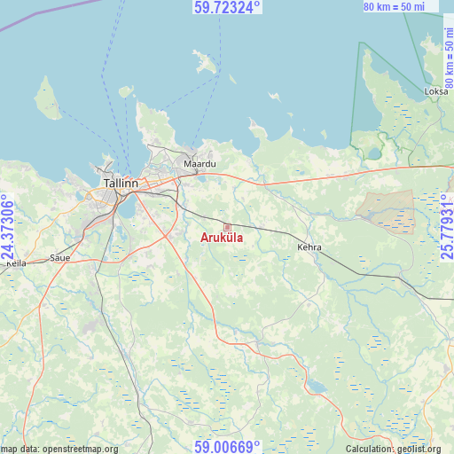
Aruküla GPS coordinates[2]
59° 22' 0.696" North, 25° 4' 34.248" East
| Map corner | latitude | longitude |
|---|---|---|
| Upper-left | 59.72324°, | 24.37306° |
| Center: | 59.36686°, | 25.07618° |
| Lower-right: | 59.00669°, | 25.77931° |
| Map W x H: | 79.7×79.7 km | = 49.5×49.5mi |
| max Lat: | 59.57639° ⇑16.8% North |
| Aruküla: | 59.36686° |
| min Lat: | ⇓83.2% South 57.72778° |
| min Long | Aruküla | max Long |
| 22.24646° | 25.07618° | 28.19028° |
| W 41.1%⇐ | ⇒58.9% E |
Elevation
Elevation of Aruküla is 50 m = 164 ft, and this is 3.2 m = 10 ft below average elevation for this country.
| Max E: |
141 m = 463 ft | 55.8% |
| Avg. | 53.2 m = 175 ft | |
| Aruküla | 50 m = 164 ft | |
Min E: |
6 m = 20 ft | 44.2% |
See also: Estonia elevation on elevation.city.
Geographical zone
Aruküla is located in North temperate zone (between Tropic of Cancer and the Arctic Circle). Distance of this North polar circle is 800.2 km =497.2 mi to North.| Distance of | km | miles | from Aruküla |
|---|---|---|---|
| North Pole | 3406.1 | 2116.5 | to North |
| Arctic Circle | 800.2 | 497.2 | to North |
| Tropic Cancer | 3995.1 | 2482.4 | to South |
| Equator | 6601 | 4101.7 | to South |


Nearby cities:
15 places around Aruküla: (largest is in red/bold)
• Jüri
10.4 km =6.5 mi,  262°
262°
• Kehra
14.3 km =8.9 mi,  103°
103°
• Kiili
15 km =9.3 mi,  244°
244°
• Kose
15.3 km =9.5 mi,  312°
312°
• Kostivere
6.8 km =4.2 mi,  10°
10°
• Lagedi
8.8 km =5.5 mi,  298°
298°
• Lehtmetsa
16.7 km =10.4 mi,  108°
108°
• Loo
10.1 km =6.3 mi, 314°
• Luige
17.6 km =10.9 mi, 255°
• Maardu
12.2 km =7.6 mi,  334°
334°
• Peetri
15.1 km =9.4 mi,  281°
281°
• Raasiku
6.1 km =3.8 mi,  90°
90°
• Randvere
18.4 km =11.4 mi, 328°
• Vaida
10.6 km =6.6 mi,  211°
211°
• Valkla
18.3 km =11.4 mi,  49°
49°
Sources, notices
• [Note1] Compared only with cities in Estonia existing in our database
• [Src1] Map data: © OpenStreetMap contributors (CC-BY-SA)
• [Src2] Other city data from geonames.org with taken over terms of usage.
• [Src3] Geographical zone / Annual Mean Temperature by Robert A. Rohde @ Wikipedia
