Tavernes Blanques geodata
Tavernes Blanques (Valencia) is a seat of a third-order administrative division; located in Spain in Europe/Madrid (GMT+2) time zone. With population of 9,033 people, there are 889 cities with bigger population in this country. Compared to other cities in Spain, 76.9% of cities are located further ↑North; 83.5% of cities are located further ←West and 98.7% of cities have higher elevation than Tavernes Blanques. Note1


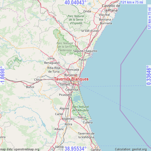
Tavernes Blanques GPS coordinates[2]
39° 30' 0" North, 0° 22' 0.012" West
| Map corner | latitude | longitude |
|---|---|---|
| Upper-left | 40.04043°, | -1.0698° |
| Center: | 39.5°, | -0.36667° |
| Lower-right: | 38.95534°, | 0.33646° |
| Map W x H: | 120.7×120.7 km | = 75×75mi |
| max Lat: | 43.74134° ⇑76.9% North |
| Tavernes Blanques: | 39.5° |
| min Lat: | ⇓23.1% South 27.64134° |
| min Long | Tavernes Blanqu | max Long |
| -18.00367° | -0.36667° | 4.2899° |
| W 83.5%⇐ | ⇒16.5% E |
Elevation
Elevation of Tavernes Blanques is 9 m = 30 ft, and this is 589 m = 1932 ft below average elevation for this country.
| Max E: |
1682 m = 5518 ft | 98.7% |
| Avg. | 598 m = 1962 ft | |
| Tavernes Blanques | 9 m = 30 ft | |
Min E: |
0 m = 0 ft | 1.3% |
See also: Spain elevation on elevation.city.
Geographical zone
Tavernes Blanques is located in North temperate zone (between Tropic of Cancer and the Arctic Circle). Distance of this Northern Tropic circle is 1786.1 km =1109.8 mi to South.| Distance of | km | miles | from Tavernes Blanques |
|---|---|---|---|
| North Pole | 5615.1 | 3489.1 | to North |
| Arctic Circle | 3009.2 | 1869.8 | to North |
| Tropic Cancer | 1786.1 | 1109.8 | to South |
| Equator | 4392 | 2729.1 | to South |


Nearby cities:
15 places around Tavernes Blanques: (largest is in red/bold)
• Albalat dels Sorells
4 km =2.5 mi,  21°
21°
• Alboraya
1.4 km =0.9 mi,  90°
90°
• Alfara del Patriarca
5.7 km =3.5 mi,  345°
345°
• Bonrepòs i Mirambell
1.9 km =1.2 mi,  0°
0°
• Burjassot
4.1 km =2.5 mi,  285°
285°
• Emperador
6.3 km =3.9 mi,  27°
27°
• Foios
4 km =2.5 mi, 21°
• Godella
5.7 km =3.5 mi,  310°
310°
• Meliana
4.7 km =2.9 mi,  37°
37°
• Mislata
5.2 km =3.2 mi,  238°
238°
• Moncada
5.6 km =3.5 mi,  333°
333°
• Rocafort
4.7 km =2.9 mi,  322°
322°
• Valencia
3.5 km =2.2 mi,  195°
195°
• Vinalesa
3.7 km =2.3 mi, 0°
• Xirivella
6.3 km =3.9 mi,  233°
233°
Sources, notices
• [Note1] Compared only with cities in Spain existing in our database
• [Src1] Map data: © OpenStreetMap contributors (CC-BY-SA)
• [Src2] Other city data from geonames.org with taken over terms of usage.
• [Src3] Geographical zone / Annual Mean Temperature by Robert A. Rohde @ Wikipedia
