Moncada geodata
Moncada (Valencia) is a seat of a third-order administrative division; located in Spain in Europe/Madrid (GMT+2) time zone. With population of 21,900 people, there are 431 cities with bigger population in this country. Compared to other cities in Spain, 76.4% of cities are located further ↑North; 83.3% of cities are located further ←West and 93.6% of cities have higher elevation than Moncada. Note1


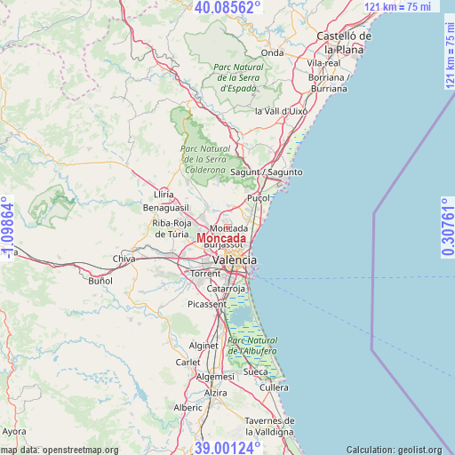
Moncada GPS coordinates[2]
39° 32' 43.98" North, 0° 23' 43.836" West
| Map corner | latitude | longitude |
|---|---|---|
| Upper-left | 40.08562°, | -1.09864° |
| Center: | 39.54555°, | -0.39551° |
| Lower-right: | 39.00124°, | 0.30761° |
| Map W x H: | 120.6×120.6 km | = 74.9×74.9mi |
| max Lat: | 43.74134° ⇑76.4% North |
| Moncada: | 39.54555° |
| min Lat: | ⇓23.6% South 27.64134° |
| min Long | Moncada | max Long |
| -18.00367° | -0.39551° | 4.2899° |
| W 83.3%⇐ | ⇒16.7% E |
Elevation
Elevation of Moncada is 34 m = 112 ft, and this is 564 m = 1850 ft below average elevation for this country.
| Max E: |
1682 m = 5518 ft | 93.6% |
| Avg. | 598 m = 1962 ft | |
| Moncada | 34 m = 112 ft | |
Min E: |
0 m = 0 ft | 6.4% |
See also: Spain elevation on elevation.city.
Geographical zone
Moncada is located in North temperate zone (between Tropic of Cancer and the Arctic Circle). Distance of this Northern Tropic circle is 1791.1 km =1112.9 mi to South.| Distance of | km | miles | from Moncada |
|---|---|---|---|
| North Pole | 5610 | 3485.9 | to North |
| Arctic Circle | 3004.1 | 1866.7 | to North |
| Tropic Cancer | 1791.1 | 1112.9 | to South |
| Equator | 4397.1 | 2732.2 | to South |


Nearby cities:
15 places around Moncada: (largest is in red/bold)
• Albalat dels Sorells
4.1 km =2.5 mi,  109°
109°
• Alboraya
6.4 km =4 mi,  142°
142°
• Alfara del Patriarca
1.2 km =0.7 mi,  64°
64°
• Bonrepòs i Mirambell
4.1 km =2.5 mi, 142°
• Burjassot
4.3 km =2.7 mi,  200°
200°
• Emperador
5.4 km =3.4 mi,  84°
84°
• Foios
4.1 km =2.5 mi, 109°
• Godella
2.3 km =1.4 mi,  233°
233°
• Massamagrell
5.8 km =3.6 mi,  66°
66°
• Meliana
5.5 km =3.4 mi,  104°
104°
• Museros
4.6 km =2.9 mi, 58°
• Paterna
6.2 km =3.9 mi,  219°
219°
• Rocafort
1.4 km =0.9 mi, 195°
• Tavernes Blanques
5.6 km =3.5 mi,  153°
153°
• Vinalesa
2.8 km =1.7 mi,  118°
118°
Sources, notices
• [Note1] Compared only with cities in Spain existing in our database
• [Src1] Map data: © OpenStreetMap contributors (CC-BY-SA)
• [Src2] Other city data from geonames.org with taken over terms of usage.
• [Src3] Geographical zone / Annual Mean Temperature by Robert A. Rohde @ Wikipedia
