Quintanar del Rey geodata
Quintanar del Rey (Castille-La Mancha) is a seat of a third-order administrative division; located in Spain in Europe/Madrid (GMT+2) time zone. With population of 7,539 people, there are 976 cities with bigger population in this country. Compared to other cities in Spain, 78.4% of cities are located further ↑North; 68.1% of cities are located further ←West and 57% of cities have lower elevation than Quintanar del Rey. Note1
Administrative division(s):
- Level 1: Castille-La Mancha
- Level 2: Provincia de Cuenca
- Level 3: Quintanar del Rey


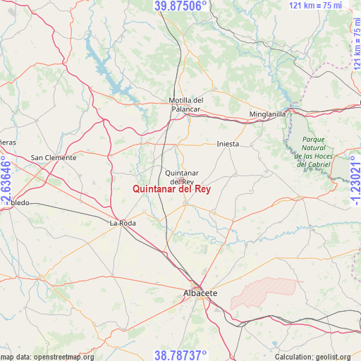
Quintanar del Rey GPS coordinates[2]
39° 19' 59.988" North, 1° 55' 59.988" West
| Map corner | latitude | longitude |
|---|---|---|
| Upper-left | 39.87506°, | -2.63646° |
| Center: | 39.33333°, | -1.93333° |
| Lower-right: | 38.78737°, | -1.23021° |
| Map W x H: | 120.9×120.9 km | = 75.1×75.1mi |
| max Lat: | 43.74134° ⇑78.4% North |
| Quintanar del Rey: | 39.33333° |
| min Lat: | ⇓21.6% South 27.64134° |
| min Long | Quintanar del R | max Long |
| -18.00367° | -1.93333° | 4.2899° |
| W 68.1%⇐ | ⇒31.9% E |
Elevation
Elevation of Quintanar del Rey is 723 m = 2372 ft, and this is 125 m = 410 ft above average elevation for this country.
| Max E: |
1682 m = 5518 ft | 43% |
| Quintanar del Rey | 723 m 2372 ft | |
| Avg. | 598 m = 1962 ft | |
Min E: |
0 m = 0 ft | 57% |
See also: Spain elevation on elevation.city.
Geographical zone
Quintanar del Rey is located in North temperate zone (between Tropic of Cancer and the Arctic Circle). Distance of this Northern Tropic circle is 1767.5 km =1098.3 mi to South.| Distance of | km | miles | from Quintanar del Rey |
|---|---|---|---|
| North Pole | 5633.6 | 3500.6 | to North |
| Arctic Circle | 3027.7 | 1881.3 | to North |
| Tropic Cancer | 1767.5 | 1098.3 | to South |
| Equator | 4373.5 | 2717.6 | to South |


Nearby cities:
15 places around Quintanar del Rey: (largest is in red/bold)
• Casas de Benítez
17.6 km =10.9 mi,  282°
282°
• Casas de Guijarro
20.2 km =12.6 mi, 275°
• Casasimarro
9.4 km =5.8 mi,  293°
293°
• El Peral
18.8 km =11.7 mi,  8°
8°
• El Picazo
18.3 km =11.4 mi,  315°
315°
• Fuensanta
16 km =9.9 mi,  225°
225°
• Iniesta
19.3 km =12 mi,  54°
54°
• Ledaña
20.4 km =12.7 mi,  79°
79°
• Madrigueras
16 km =9.9 mi,  134°
134°
• Montalvos
19.9 km =12.4 mi,  201°
201°
• Navas de Jorquera
19.5 km =12.1 mi,  106°
106°
• Tarazona de la Mancha
9.4 km =5.8 mi,  171°
171°
• Villagarcía del Llano
8.8 km =5.5 mi,  102°
102°
• Villagordo del Júcar
12.1 km =7.5 mi,  252°
252°
• Villanueva de la Jara
11.1 km =6.9 mi,  0°
0°
Sources, notices
• [Note1] Compared only with cities in Spain existing in our database
• [Src1] Map data: © OpenStreetMap contributors (CC-BY-SA)
• [Src2] Other city data from geonames.org with taken over terms of usage.
• [Src3] Geographical zone / Annual Mean Temperature by Robert A. Rohde @ Wikipedia
