El Peral geodata
El Peral (Castille-La Mancha) is a populated place; located in Spain in Europe/Madrid (GMT+2) time zone. With population of 738 people, there are 3330 cities with bigger population in this country. Compared to other cities in Spain, 76.9% of cities are located further ↑North; 68.4% of cities are located further ←West and 66.9% of cities have lower elevation than El Peral. Note1
Administrative division(s):
- Level 1: Castille-La Mancha
- Level 2: Provincia de Cuenca
- Level 3: Peral, El


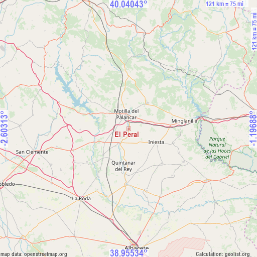
El Peral GPS coordinates[2]
39° 30' 0" North, 1° 54' 0" West
| Map corner | latitude | longitude |
|---|---|---|
| Upper-left | 40.04043°, | -2.60313° |
| Center: | 39.5°, | -1.9° |
| Lower-right: | 38.95534°, | -1.19688° |
| Map W x H: | 120.7×120.7 km | = 75×75mi |
| max Lat: | 43.74134° ⇑76.9% North |
| El Peral: | 39.5° |
| min Lat: | ⇓23.1% South 27.64134° |
| min Long | El Peral | max Long |
| -18.00367° | -1.9° | 4.2899° |
| W 68.4%⇐ | ⇒31.6% E |
Elevation
Elevation of El Peral is 791 m = 2595 ft, and this is 193 m = 633 ft above average elevation for this country.
| Max E: |
1682 m = 5518 ft | 33.1% |
| El Peral | 791 m 2595 ft | |
| Avg. | 598 m = 1962 ft | |
Min E: |
0 m = 0 ft | 66.9% |
See also: Spain elevation on elevation.city.
Geographical zone
El Peral is located in North temperate zone (between Tropic of Cancer and the Arctic Circle). Distance of this Northern Tropic circle is 1786.1 km =1109.8 mi to South.| Distance of | km | miles | from El Peral |
|---|---|---|---|
| North Pole | 5615.1 | 3489.1 | to North |
| Arctic Circle | 3009.2 | 1869.8 | to North |
| Tropic Cancer | 1786.1 | 1109.8 | to South |
| Equator | 4392 | 2729.1 | to South |


Nearby cities:
15 places around El Peral: (largest is in red/bold)
• Alarcón
16.7 km =10.4 mi,  289°
289°
• Campillo de Altobuey
14 km =8.7 mi,  37°
37°
• Casasimarro
18.7 km =11.6 mi,  217°
217°
• Castillejo de Iniesta
12 km =7.5 mi,  72°
72°
• El Picazo
16.7 km =10.4 mi,  250°
250°
• Gabaldón
13.3 km =8.3 mi,  347°
347°
• Graja de Iniesta
20.1 km =12.5 mi,  84°
84°
• Iniesta
14.9 km =9.3 mi,  119°
119°
• Motilla del Palancar
7.5 km =4.7 mi,  10°
10°
• Puebla del Salvador
21.3 km =13.2 mi, 69°
• Quintanar del Rey
18.8 km =11.7 mi,  188°
188°
• Valhermoso de la Fuente
12.5 km =7.8 mi,  306°
306°
• Valverdejo
16.4 km =10.2 mi,  322°
322°
• Villagarcía del Llano
21.2 km =13.2 mi,  164°
164°
• Villanueva de la Jara
7.9 km =4.9 mi,  201°
201°
Sources, notices
• [Note1] Compared only with cities in Spain existing in our database
• [Src1] Map data: © OpenStreetMap contributors (CC-BY-SA)
• [Src2] Other city data from geonames.org with taken over terms of usage.
• [Src3] Geographical zone / Annual Mean Temperature by Robert A. Rohde @ Wikipedia
