L'Olleria geodata
L'Olleria (Valencia) is a populated place; located in Spain in Europe/Madrid (GMT+2) time zone. With population of 7,648 people, there are 969 cities with bigger population in this country. Compared to other cities in Spain, 82% of cities are located further ↑North; 81.1% of cities are located further ←West and 78.1% of cities have higher elevation than L'Olleria. Note1


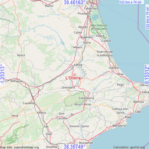
L'Olleria GPS coordinates[2]
38° 55' 0.012" North, 0° 33' 0" West
| Map corner | latitude | longitude |
|---|---|---|
| Upper-left | 39.46163°, | -1.25313° |
| Center: | 38.91667°, | -0.55° |
| Lower-right: | 38.36749°, | 0.15312° |
| Map W x H: | 121.7×121.7 km | = 75.6×75.6mi |
| max Lat: | 43.74134° ⇑82% North |
| L'Olleria: | 38.91667° |
| min Lat: | ⇓18% South 27.64134° |
| min Long | L'Olleria | max Long |
| -18.00367° | -0.55° | 4.2899° |
| W 81.1%⇐ | ⇒18.9% E |
Elevation
Elevation of L'Olleria is 255 m = 837 ft, and this is 343 m = 1125 ft below average elevation for this country.
| Max E: |
1682 m = 5518 ft | 78.1% |
| Avg. | 598 m = 1962 ft | |
| L'Olleria | 255 m = 837 ft | |
Min E: |
0 m = 0 ft | 21.9% |
See also: Spain elevation on elevation.city.
Geographical zone
L'Olleria is located in North temperate zone (between Tropic of Cancer and the Arctic Circle). Distance of this Northern Tropic circle is 1721.2 km =1069.5 mi to South.| Distance of | km | miles | from L'Olleria |
|---|---|---|---|
| North Pole | 5679.9 | 3529.3 | to North |
| Arctic Circle | 3074 | 1910.1 | to North |
| Tropic Cancer | 1721.2 | 1069.5 | to South |
| Equator | 4327.1 | 2688.7 | to South |


Nearby cities:
15 places around L'Olleria: (largest is in red/bold)
• Aielo de Malferit
4.7 km =2.9 mi,  217°
217°
• Alfarrasí
4.7 km =2.9 mi,  113°
113°
• Bellús
6.3 km =3.9 mi,  59°
59°
• Benisuera
6.3 km =3.9 mi,  93°
93°
• Bufali
6.2 km =3.9 mi,  151°
151°
• Canals
5.9 km =3.7 mi,  329°
329°
• Cerdà
7.6 km =4.7 mi,  348°
348°
• Guadasequies
5.6 km =3.5 mi,  80°
80°
• L'Alcúdia de Crespìns
6.3 km =3.9 mi, 332°
• Montaberner
5.5 km =3.4 mi,  122°
122°
• Novelé
7.1 km =4.4 mi,  1°
1°
• Palomar
8.1 km =5 mi, 149°
• Sempere
5.9 km =3.7 mi, 86°
• Torrella
7.7 km =4.8 mi, 348°
• Vallés
7.6 km =4.7 mi,  355°
355°
Sources, notices
• [Note1] Compared only with cities in Spain existing in our database
• [Src1] Map data: © OpenStreetMap contributors (CC-BY-SA)
• [Src2] Other city data from geonames.org with taken over terms of usage.
• [Src3] Geographical zone / Annual Mean Temperature by Robert A. Rohde @ Wikipedia
