Montaberner geodata
Montaberner (Valencia) is a populated place; located in Spain in Europe/Madrid (GMT+2) time zone. With population of 1,779 people, there are 2299 cities with bigger population in this country. Compared to other cities in Spain, 82.2% of cities are located further ↑North; 81.8% of cities are located further ←West and 82.1% of cities have higher elevation than Montaberner. Note1


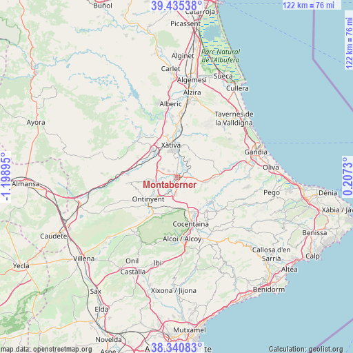
Montaberner GPS coordinates[2]
38° 53' 24.756" North, 0° 29' 44.952" West
| Map corner | latitude | longitude |
|---|---|---|
| Upper-left | 39.43538°, | -1.19895° |
| Center: | 38.89021°, | -0.49582° |
| Lower-right: | 38.34083°, | 0.2073° |
| Map W x H: | 121.7×121.7 km | = 75.6×75.6mi |
| max Lat: | 43.74134° ⇑82.2% North |
| Montaberner: | 38.89021° |
| min Lat: | ⇓17.8% South 27.64134° |
| min Long | Montaberner | max Long |
| -18.00367° | -0.49582° | 4.2899° |
| W 81.8%⇐ | ⇒18.2% E |
Elevation
Elevation of Montaberner is 184 m = 604 ft, and this is 414 m = 1358 ft below average elevation for this country.
| Max E: |
1682 m = 5518 ft | 82.1% |
| Avg. | 598 m = 1962 ft | |
| Montaberner | 184 m = 604 ft | |
Min E: |
0 m = 0 ft | 17.9% |
See also: Spain elevation on elevation.city.
Geographical zone
Montaberner is located in North temperate zone (between Tropic of Cancer and the Arctic Circle). Distance of this Northern Tropic circle is 1718.3 km =1067.7 mi to South.| Distance of | km | miles | from Montaberner |
|---|---|---|---|
| North Pole | 5682.9 | 3531.2 | to North |
| Arctic Circle | 3077 | 1912 | to North |
| Tropic Cancer | 1718.3 | 1067.7 | to South |
| Equator | 4324.2 | 2686.9 | to South |


Nearby cities:
15 places around Montaberner: (largest is in red/bold)
• Aielo de Malferit
7.6 km =4.7 mi,  264°
264°
• Albaida
6.1 km =3.8 mi,  197°
197°
• Alfarrasí
1.1 km =0.7 mi,  341°
341°
• Atzeneta d'Albaida
6.3 km =3.9 mi,  183°
183°
• Bellús
6.2 km =3.9 mi,  7°
7°
• Benissoda
6.6 km =4.1 mi, 195°
• Benisuera
3 km =1.9 mi,  31°
31°
• Bufali
3.1 km =1.9 mi,  215°
215°
• Bèlgida
5.1 km =3.2 mi,  150°
150°
• Carrícola
5.8 km =3.6 mi,  159°
159°
• Guadasequies
4 km =2.5 mi, 12°
• L'Olleria
5.5 km =3.4 mi,  302°
302°
• Otos
6 km =3.7 mi,  131°
131°
• Palomar
4.1 km =2.5 mi,  188°
188°
• Sempere
3.6 km =2.2 mi,  20°
20°
Sources, notices
• [Note1] Compared only with cities in Spain existing in our database
• [Src1] Map data: © OpenStreetMap contributors (CC-BY-SA)
• [Src2] Other city data from geonames.org with taken over terms of usage.
• [Src3] Geographical zone / Annual Mean Temperature by Robert A. Rohde @ Wikipedia
