Xàtiva geodata
Xàtiva (Valencia) is a seat of a third-order administrative division; located in Spain in Europe/Madrid (GMT+2) time zone. With population of 29,386 people, there are 311 cities with bigger population in this country. Compared to other cities in Spain, 81% of cities are located further ↑North; 81.5% of cities are located further ←West and 87.2% of cities have higher elevation than Xàtiva. Note1


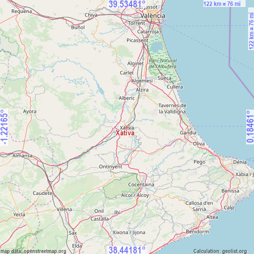
Xàtiva GPS coordinates[2]
38° 59' 25.512" North, 0° 31' 6.672" West
| Map corner | latitude | longitude |
|---|---|---|
| Upper-left | 39.53481°, | -1.22165° |
| Center: | 38.99042°, | -0.51852° |
| Lower-right: | 38.44181°, | 0.18461° |
| Map W x H: | 121.5×121.5 km | = 75.5×75.5mi |
| max Lat: | 43.74134° ⇑81% North |
| Xàtiva: | 38.99042° |
| min Lat: | ⇓19% South 27.64134° |
| min Long | Xàtiva | max Long |
| -18.00367° | -0.51852° | 4.2899° |
| W 81.5%⇐ | ⇒18.5% E |
Elevation
Elevation of Xàtiva is 108 m = 354 ft, and this is 490 m = 1608 ft below average elevation for this country.
| Max E: |
1682 m = 5518 ft | 87.2% |
| Avg. | 598 m = 1962 ft | |
| Xàtiva | 108 m = 354 ft | |
Min E: |
0 m = 0 ft | 12.8% |
See also: Spain elevation on elevation.city.
Geographical zone
Xàtiva is located in North temperate zone (between Tropic of Cancer and the Arctic Circle). Distance of this Northern Tropic circle is 1729.4 km =1074.6 mi to South.| Distance of | km | miles | from Xàtiva |
|---|---|---|---|
| North Pole | 5671.7 | 3524.2 | to North |
| Arctic Circle | 3065.8 | 1905 | to North |
| Tropic Cancer | 1729.4 | 1074.6 | to South |
| Equator | 4335.3 | 2693.8 | to South |


Nearby cities:
15 places around Xàtiva: (largest is in red/bold)
• Bellús
5.7 km =3.5 mi,  151°
151°
• Canals
6.5 km =4 mi,  241°
241°
• Cerdà
4.2 km =2.6 mi,  259°
259°
• Genovés
4.2 km =2.6 mi,  91°
91°
• L'Alcúdia de Crespìns
6.2 km =3.9 mi, 244°
• L'Ènova
7.3 km =4.5 mi,  24°
24°
• Llanera de Ranes
4.9 km =3 mi,  276°
276°
• Llosa de Ranes
3.9 km =2.4 mi,  334°
334°
• Lugar Nuevo de Fenollet
5.2 km =3.2 mi,  60°
60°
• Manuel
7.1 km =4.4 mi, 20°
• Novelé
2.8 km =1.7 mi,  246°
246°
• Rotglá y Corbera
4.3 km =2.7 mi,  291°
291°
• Sellent
7.6 km =4.7 mi,  307°
307°
• Torrella
4.3 km =2.7 mi, 261°
• Vallés
3.4 km =2.1 mi, 260°
Sources, notices
• [Note1] Compared only with cities in Spain existing in our database
• [Src1] Map data: © OpenStreetMap contributors (CC-BY-SA)
• [Src2] Other city data from geonames.org with taken over terms of usage.
• [Src3] Geographical zone / Annual Mean Temperature by Robert A. Rohde @ Wikipedia
