Manuel geodata
Manuel (Valencia) is a seat of a third-order administrative division; located in Spain in Europe/Madrid (GMT+2) time zone. With population of 2,497 people, there are 1902 cities with bigger population in this country. Compared to other cities in Spain, 80.6% of cities are located further ↑North; 81.8% of cities are located further ←West and 90.2% of cities have higher elevation than Manuel. Note1


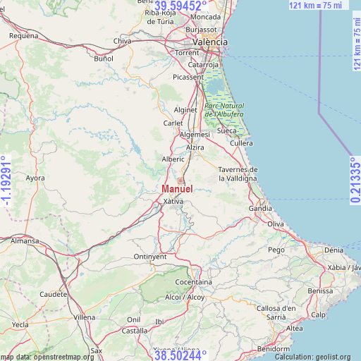
Manuel GPS coordinates[2]
39° 3' 2.124" North, 0° 29' 23.208" West
| Map corner | latitude | longitude |
|---|---|---|
| Upper-left | 39.59452°, | -1.19291° |
| Center: | 39.05059°, | -0.48978° |
| Lower-right: | 38.50244°, | 0.21335° |
| Map W x H: | 121.4×121.4 km | = 75.4×75.4mi |
| max Lat: | 43.74134° ⇑80.6% North |
| Manuel: | 39.05059° |
| min Lat: | ⇓19.4% South 27.64134° |
| min Long | Manuel | max Long |
| -18.00367° | -0.48978° | 4.2899° |
| W 81.8%⇐ | ⇒18.2% E |
Elevation
Elevation of Manuel is 63 m = 207 ft, and this is 535 m = 1755 ft below average elevation for this country.
| Max E: |
1682 m = 5518 ft | 90.2% |
| Avg. | 598 m = 1962 ft | |
| Manuel | 63 m = 207 ft | |
Min E: |
0 m = 0 ft | 9.8% |
See also: Spain elevation on elevation.city.
Geographical zone
Manuel is located in North temperate zone (between Tropic of Cancer and the Arctic Circle). Distance of this Northern Tropic circle is 1736.1 km =1078.8 mi to South.| Distance of | km | miles | from Manuel |
|---|---|---|---|
| North Pole | 5665 | 3520.1 | to North |
| Arctic Circle | 3059.2 | 1900.9 | to North |
| Tropic Cancer | 1736.1 | 1078.8 | to South |
| Equator | 4342 | 2698 | to South |


Nearby cities:
15 places around Manuel: (largest is in red/bold)
• Alcàntera de Xúquer
5.5 km =3.4 mi,  288°
288°
• Barxeta
7.4 km =4.6 mi,  120°
120°
• Beneixida
5.5 km =3.4 mi, 288°
• Càrcer
6.9 km =4.3 mi, 285°
• Gavarda
6.3 km =3.9 mi,  305°
305°
• Genovés
7 km =4.3 mi,  165°
165°
• L'Ènova
0.6 km =0.4 mi,  96°
96°
• La Pobla Llarga
4.2 km =2.6 mi,  28°
28°
• Llosa de Ranes
5.3 km =3.3 mi,  232°
232°
• Lugar Nuevo de Fenollet
4.6 km =2.9 mi,  154°
154°
• Rafelguaraf
3 km =1.9 mi,  88°
88°
• San Juan de Énova
2.3 km =1.4 mi,  5°
5°
• Senyera
2 km =1.2 mi,  333°
333°
• Villanueva de Castellón
3.5 km =2.2 mi, 327°
• Xàtiva
7.1 km =4.4 mi,  200°
200°
Sources, notices
• [Note1] Compared only with cities in Spain existing in our database
• [Src1] Map data: © OpenStreetMap contributors (CC-BY-SA)
• [Src2] Other city data from geonames.org with taken over terms of usage.
• [Src3] Geographical zone / Annual Mean Temperature by Robert A. Rohde @ Wikipedia
