Haría geodata
Haría (Canary Islands) is a seat of a third-order administrative division; located in Spain in Atlantic/Canary (GMT+1) time zone. With population of 4,833 people, there are 1340 cities with bigger population in this country. Compared to other cities in Spain, 98.4% of cities are located further ↑North; 98.4% of cities are located further →East and 75.7% of cities have higher elevation than Haría. Note1


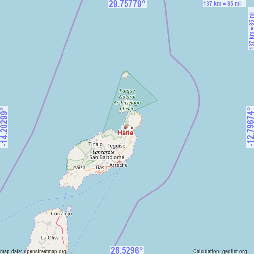
Haría GPS coordinates[2]
29° 8' 43.908" North, 13° 29' 59.496" West
| Map corner | latitude | longitude |
|---|---|---|
| Upper-left | 29.75779°, | -14.20299° |
| Center: | 29.14553°, | -13.49986° |
| Lower-right: | 28.5296°, | -12.79674° |
| Map W x H: | 136.6×136.6 km | = 84.9×84.9mi |
| max Lat: | 43.74134° ⇑98.4% North |
| Haría: | 29.14553° |
| min Lat: | ⇓1.6% South 27.64134° |
| min Long | Haría | max Long |
| -18.00367° | -13.49986° | 4.2899° |
| W 1.6%⇐ | ⇒98.4% E |
Elevation
Elevation of Haría is 287 m = 942 ft, and this is 311 m = 1020 ft below average elevation for this country.
| Max E: |
1682 m = 5518 ft | 75.7% |
| Avg. | 598 m = 1962 ft | |
| Haría | 287 m = 942 ft | |
Min E: |
0 m = 0 ft | 24.3% |
See also: Spain elevation on elevation.city.
Geographical zone
Haría is located in North temperate zone (between Tropic of Cancer and the Arctic Circle). Distance of this Northern Tropic circle is 634.8 km =394.4 mi to South.| Distance of | km | miles | from Haría |
|---|---|---|---|
| North Pole | 6766.4 | 4204.4 | to North |
| Arctic Circle | 4160.5 | 2585.2 | to North |
| Tropic Cancer | 634.8 | 394.4 | to South |
| Equator | 3240.7 | 2013.7 | to South |


Nearby cities:
15 places around Haría: (largest is in red/bold)
• Arrecife
20.8 km =12.9 mi,  192°
192°
• Caleta de Sebo
9.6 km =6 mi,  357°
357°
• Costa Teguise
16.4 km =10.2 mi,  179°
179°
• Guatiza
8.2 km =5.1 mi,  165°
165°
• La Santa
16.8 km =10.4 mi,  255°
255°
• Mala
6.1 km =3.8 mi,  153°
153°
• Mácher
28.7 km =17.8 mi,  220°
220°
• Nazaret
13.5 km =8.4 mi,  207°
207°
• Puerto del Carmen
29.5 km =18.3 mi, 213°
• Punta de Mujeres
5.1 km =3.2 mi,  88°
88°
• San Bartolomé
19.5 km =12.1 mi, 214°
• Soo
13 km =8.1 mi,  246°
246°
• Teguise
11.3 km =7 mi, 213°
• Tinajo
19.4 km =12.1 mi,  241°
241°
• Tías
24.9 km =15.5 mi, 214°
Sources, notices
• [Note1] Compared only with cities in Spain existing in our database
• [Src1] Map data: © OpenStreetMap contributors (CC-BY-SA)
• [Src2] Other city data from geonames.org with taken over terms of usage.
• [Src3] Geographical zone / Annual Mean Temperature by Robert A. Rohde @ Wikipedia
