Corralejo geodata
Corralejo (Canary Islands) is a populated place; located in Spain in Atlantic/Canary (GMT+1) time zone. With population of 13,618 people, there are 680 cities with bigger population in this country. Compared to other cities in Spain, 98.7% of cities are located further ↑North; 98.7% of cities are located further →East and 97.3% of cities have higher elevation than Corralejo. Note1
Administrative division(s):
- Level 1: Canary Islands
- Level 2: Provincia de Las Palmas
- Level 3: Oliva, La


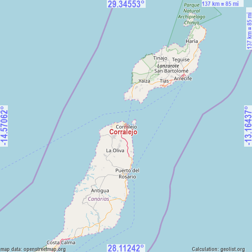
Corralejo GPS coordinates[2]
28° 43' 50.844" North, 13° 52' 2.964" West
| Map corner | latitude | longitude |
|---|---|---|
| Upper-left | 29.34553°, | -14.57062° |
| Center: | 28.73079°, | -13.86749° |
| Lower-right: | 28.11242°, | -13.16437° |
| Map W x H: | 137.1×137.1 km | = 85.2×85.2mi |
| max Lat: | 43.74134° ⇑98.7% North |
| Corralejo: | 28.73079° |
| min Lat: | ⇓1.3% South 27.64134° |
| min Long | Corralejo | max Long |
| -18.00367° | -13.86749° | 4.2899° |
| W 1.3%⇐ | ⇒98.7% E |
Elevation
Elevation of Corralejo is 14 m = 46 ft, and this is 584 m = 1916 ft below average elevation for this country.
| Max E: |
1682 m = 5518 ft | 97.3% |
| Avg. | 598 m = 1962 ft | |
| Corralejo | 14 m = 46 ft | |
Min E: |
0 m = 0 ft | 2.7% |
See also: Spain elevation on elevation.city.
Geographical zone
Corralejo is located in North temperate zone (between Tropic of Cancer and the Arctic Circle). Distance of this Northern Tropic circle is 588.6 km =365.7 mi to South.| Distance of | km | miles | from Corralejo |
|---|---|---|---|
| North Pole | 6812.5 | 4233.1 | to North |
| Arctic Circle | 4206.6 | 2613.9 | to North |
| Tropic Cancer | 588.6 | 365.7 | to South |
| Equator | 3194.6 | 1985 | to South |


Nearby cities:
15 places around Corralejo: (largest is in red/bold)
• Antigua
37.1 km =23.1 mi,  202°
202°
• Arrecife
40.5 km =25.2 mi,  50°
50°
• Betancuría
38.8 km =24.1 mi,  208°
208°
• El Cotillo
14.6 km =9.1 mi,  248°
248°
• La Oliva
14.7 km =9.1 mi, 204°
• Mácher
29.7 km =18.5 mi,  35°
35°
• Nazaret
45.2 km =28.1 mi, 40°
• Playa Blanca
15.3 km =9.5 mi,  14°
14°
• Puerto del Carmen
29 km =18 mi, 42°
• Puerto del Rosario
25.6 km =15.9 mi,  178°
178°
• San Bartolomé
38.9 km =24.2 mi, 39°
• Tinajo
41.4 km =25.7 mi,  26°
26°
• Tías
33.5 km =20.8 mi, 40°
• Uga
27.2 km =16.9 mi, 26°
• Yaiza
27 km =16.8 mi,  21°
21°
Sources, notices
• [Note1] Compared only with cities in Spain existing in our database
• [Src1] Map data: © OpenStreetMap contributors (CC-BY-SA)
• [Src2] Other city data from geonames.org with taken over terms of usage.
• [Src3] Geographical zone / Annual Mean Temperature by Robert A. Rohde @ Wikipedia
