La Oliva geodata
La Oliva (Canary Islands) is a populated place; located in Spain in Atlantic/Canary (GMT+1) time zone. With population of 21,996 people, there are 426 cities with bigger population in this country. Compared to other cities in Spain, 98.8% of cities are located further ↑North; 98.7% of cities are located further →East and 79.7% of cities have higher elevation than La Oliva. Note1
Administrative division(s):
- Level 1: Canary Islands
- Level 2: Provincia de Las Palmas
- Level 3: Oliva, La


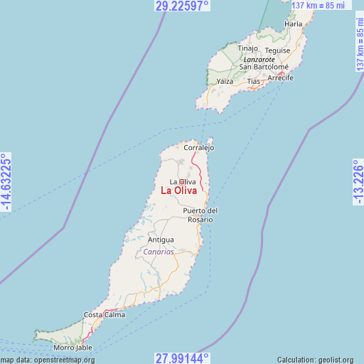
La Oliva GPS coordinates[2]
28° 36' 37.872" North, 13° 55' 44.832" West
| Map corner | latitude | longitude |
|---|---|---|
| Upper-left | 29.22597°, | -14.63225° |
| Center: | 28.61052°, | -13.92912° |
| Lower-right: | 27.99144°, | -13.226° |
| Map W x H: | 137.3×137.3 km | = 85.3×85.3mi |
| max Lat: | 43.74134° ⇑98.8% North |
| La Oliva: | 28.61052° |
| min Lat: | ⇓1.2% South 27.64134° |
| min Long | La Oliva | max Long |
| -18.00367° | -13.92912° | 4.2899° |
| W 1.3%⇐ | ⇒98.7% E |
Elevation
Elevation of La Oliva is 225 m = 738 ft, and this is 373 m = 1224 ft below average elevation for this country.
| Max E: |
1682 m = 5518 ft | 79.7% |
| Avg. | 598 m = 1962 ft | |
| La Oliva | 225 m = 738 ft | |
Min E: |
0 m = 0 ft | 20.3% |
See also: Spain elevation on elevation.city.
Geographical zone
La Oliva is located in North temperate zone (between Tropic of Cancer and the Arctic Circle). Distance of this Northern Tropic circle is 575.3 km =357.5 mi to South.| Distance of | km | miles | from La Oliva |
|---|---|---|---|
| North Pole | 6825.9 | 4241.4 | to North |
| Arctic Circle | 4220 | 2622.2 | to North |
| Tropic Cancer | 575.3 | 357.5 | to South |
| Equator | 3181.2 | 1976.7 | to South |


Nearby cities:
15 places around La Oliva: (largest is in red/bold)
• Antigua
22.4 km =13.9 mi,  201°
201°
• Arrecife
54 km =33.6 mi,  43°
43°
• Betancuría
24.2 km =15 mi,  210°
210°
• Corralejo
14.7 km =9.1 mi,  24°
24°
• El Cotillo
11 km =6.8 mi,  316°
316°
• Mácher
44.1 km =27.4 mi,  31°
31°
• Playa Blanca
29.9 km =18.6 mi, 19°
• Puerto del Carmen
43.2 km =26.8 mi, 36°
• Puerto del Rosario
13.9 km =8.6 mi,  152°
152°
• Pájara
33.8 km =21 mi, 211°
• San Bartolomé
53.2 km =33.1 mi, 35°
• Tuineje
33.9 km =21.1 mi, 199°
• Tías
47.8 km =29.7 mi, 35°
• Uga
41.8 km =26 mi, 25°
• Yaiza
41.7 km =25.9 mi, 22°
Sources, notices
• [Note1] Compared only with cities in Spain existing in our database
• [Src1] Map data: © OpenStreetMap contributors (CC-BY-SA)
• [Src2] Other city data from geonames.org with taken over terms of usage.
• [Src3] Geographical zone / Annual Mean Temperature by Robert A. Rohde @ Wikipedia
