Almoharín geodata
Almoharín (Extremadura) is a seat of a third-order administrative division; located in Spain in Europe/Madrid (GMT+2) time zone. With population of 2,040 people, there are 2136 cities with bigger population in this country. Compared to other cities in Spain, 79.6% of cities are located further ↑North; 86.6% of cities are located further →East and 74.5% of cities have higher elevation than Almoharín. Note1


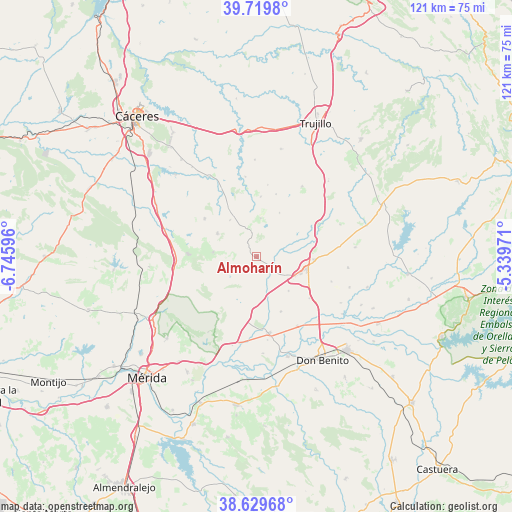
Almoharín GPS coordinates[2]
39° 10' 36.66" North, 6° 2' 34.188" West
| Map corner | latitude | longitude |
|---|---|---|
| Upper-left | 39.7198°, | -6.74596° |
| Center: | 39.17685°, | -6.04283° |
| Lower-right: | 38.62968°, | -5.33971° |
| Map W x H: | 121.2×121.2 km | = 75.3×75.3mi |
| max Lat: | 43.74134° ⇑79.6% North |
| Almoharín: | 39.17685° |
| min Lat: | ⇓20.4% South 27.64134° |
| min Long | Almoharín | max Long |
| -18.00367° | -6.04283° | 4.2899° |
| W 13.4%⇐ | ⇒86.6% E |
Elevation
Elevation of Almoharín is 303 m = 994 ft, and this is 295 m = 968 ft below average elevation for this country.
| Max E: |
1682 m = 5518 ft | 74.5% |
| Avg. | 598 m = 1962 ft | |
| Almoharín | 303 m = 994 ft | |
Min E: |
0 m = 0 ft | 25.5% |
See also: Spain elevation on elevation.city.
Geographical zone
Almoharín is located in North temperate zone (between Tropic of Cancer and the Arctic Circle). Distance of this Northern Tropic circle is 1750.1 km =1087.5 mi to South.| Distance of | km | miles | from Almoharín |
|---|---|---|---|
| North Pole | 5651 | 3511.4 | to North |
| Arctic Circle | 3045.1 | 1892.1 | to North |
| Tropic Cancer | 1750.1 | 1087.5 | to South |
| Equator | 4356.1 | 2706.8 | to South |


Nearby cities:
15 places around Almoharín: (largest is in red/bold)
• Albalá
15.1 km =9.4 mi,  305°
305°
• Alcuéscar
16.1 km =10 mi,  271°
271°
• Arroyomolinos de Montánchez
10.3 km =6.4 mi,  275°
275°
• Benquerencia
15.2 km =9.4 mi,  346°
346°
• Escurial
13.7 km =8.5 mi,  93°
93°
• Miajadas
11.9 km =7.4 mi,  103°
103°
• Montánchez
10.6 km =6.6 mi,  300°
300°
• Robledillo de Trujillo
11.6 km =7.2 mi,  27°
27°
• Salvatierra de Santiago
14.1 km =8.8 mi,  3°
3°
• Santa Ana
15.3 km =9.5 mi,  17°
17°
• Torre de Santa María
10.7 km =6.6 mi,  323°
323°
• Valdefuentes
12.8 km =8 mi,  327°
327°
• Valdemorales
3.8 km =2.4 mi, 328°
• Villamesías
16.5 km =10.3 mi,  62°
62°
• Zarza de Montánchez
9 km =5.6 mi,  5°
5°
Sources, notices
• [Note1] Compared only with cities in Spain existing in our database
• [Src1] Map data: © OpenStreetMap contributors (CC-BY-SA)
• [Src2] Other city data from geonames.org with taken over terms of usage.
• [Src3] Geographical zone / Annual Mean Temperature by Robert A. Rohde @ Wikipedia
