Zarautz geodata
Zarautz (Basque Country) is a seat of a third-order administrative division; located in Spain in Europe/Madrid (GMT+2) time zone. With population of 22,627 people, there are 411 cities with bigger population in this country. Compared to other cities in Spain, 97.4% of cities are located further ↓South; 65.1% of cities are located further ←West and 99.5% of cities have higher elevation than Zarautz. Note1


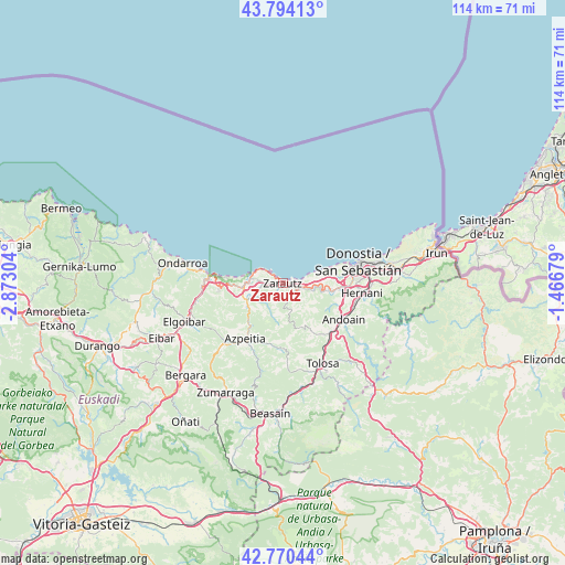
Zarautz GPS coordinates[2]
43° 17' 3.984" North, 2° 10' 11.712" West
| Map corner | latitude | longitude |
|---|---|---|
| Upper-left | 43.79413°, | -2.87304° |
| Center: | 43.28444°, | -2.16992° |
| Lower-right: | 42.77044°, | -1.46679° |
| Map W x H: | 113.8×113.8 km | = 70.7×70.7mi |
| max Lat: | 43.74134° ⇑2.6% North |
| Zarautz: | 43.28444° |
| min Lat: | ⇓97.4% South 27.64134° |
| min Long | Zarautz | max Long |
| -18.00367° | -2.16992° | 4.2899° |
| W 65.1%⇐ | ⇒34.9% E |
Elevation
Elevation of Zarautz is 6 m = 20 ft, and this is 592 m = 1942 ft below average elevation for this country.
| Max E: |
1682 m = 5518 ft | 99.5% |
| Avg. | 598 m = 1962 ft | |
| Zarautz | 6 m = 20 ft | |
Min E: |
0 m = 0 ft | 0.5% |
See also: Spain elevation on elevation.city.
Geographical zone
Zarautz is located in North temperate zone (between Tropic of Cancer and the Arctic Circle). Distance of this Northern Tropic circle is 2206.9 km =1371.3 mi to South.| Distance of | km | miles | from Zarautz |
|---|---|---|---|
| North Pole | 5194.3 | 3227.6 | to North |
| Arctic Circle | 2588.4 | 1608.4 | to North |
| Tropic Cancer | 2206.9 | 1371.3 | to South |
| Equator | 4812.8 | 2990.5 | to South |


Nearby cities:
15 places around Zarautz: (largest is in red/bold)
• Aduna
13.2 km =8.2 mi,  132°
132°
• Aia
5.5 km =3.4 mi,  161°
161°
• Aizarnazabal
6.2 km =3.9 mi,  239°
239°
• Alkiza
13.4 km =8.3 mi, 158°
• Asteasu
11.6 km =7.2 mi,  149°
149°
• Errezil
13.3 km =8.3 mi,  181°
181°
• Getaria
3.5 km =2.2 mi,  306°
306°
• Larraul
12.1 km =7.5 mi, 152°
• Lasarte
12.1 km =7.5 mi,  98°
98°
• Oria
12.7 km =7.9 mi, 104°
• Orio
3.7 km =2.3 mi, 100°
• Usurbil
9.9 km =6.2 mi, 98°
• Zestoa
8.7 km =5.4 mi, 235°
• Zizurkil
12.2 km =7.6 mi,  140°
140°
• Zumaia
6.9 km =4.3 mi,  279°
279°
Sources, notices
• [Note1] Compared only with cities in Spain existing in our database
• [Src1] Map data: © OpenStreetMap contributors (CC-BY-SA)
• [Src2] Other city data from geonames.org with taken over terms of usage.
• [Src3] Geographical zone / Annual Mean Temperature by Robert A. Rohde @ Wikipedia
