Getaria geodata
Getaria (Basque Country) is a seat of a third-order administrative division; located in Spain in Europe/Madrid (GMT+2) time zone. With population of 2,530 people, there are 1892 cities with bigger population in this country. Compared to other cities in Spain, 97.6% of cities are located further ↓South; 64.6% of cities are located further ←West and 93.9% of cities have higher elevation than Getaria. Note1


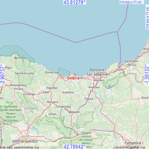
Getaria GPS coordinates[2]
43° 18' 11.736" North, 2° 12' 15.984" West
| Map corner | latitude | longitude |
|---|---|---|
| Upper-left | 43.81279°, | -2.90757° |
| Center: | 43.30326°, | -2.20444° |
| Lower-right: | 42.78942°, | -1.50132° |
| Map W x H: | 113.8×113.8 km | = 70.7×70.7mi |
| max Lat: | 43.74134° ⇑2.4% North |
| Getaria: | 43.30326° |
| min Lat: | ⇓97.6% South 27.64134° |
| min Long | Getaria | max Long |
| -18.00367° | -2.20444° | 4.2899° |
| W 64.6%⇐ | ⇒35.4% E |
Elevation
Elevation of Getaria is 32 m = 105 ft, and this is 566 m = 1857 ft below average elevation for this country.
| Max E: |
1682 m = 5518 ft | 93.9% |
| Avg. | 598 m = 1962 ft | |
| Getaria | 32 m = 105 ft | |
Min E: |
0 m = 0 ft | 6.1% |
See also: Spain elevation on elevation.city.
Geographical zone
Getaria is located in North temperate zone (between Tropic of Cancer and the Arctic Circle). Distance of this Northern Tropic circle is 2209 km =1372.6 mi to South.| Distance of | km | miles | from Getaria |
|---|---|---|---|
| North Pole | 5192.2 | 3226.3 | to North |
| Arctic Circle | 2586.3 | 1607.1 | to North |
| Tropic Cancer | 2209 | 1372.6 | to South |
| Equator | 4814.9 | 2991.8 | to South |


Nearby cities:
15 places around Getaria: (largest is in red/bold)
• Aia
8.6 km =5.3 mi,  148°
148°
• Aizarnazabal
5.9 km =3.7 mi,  205°
205°
• Asteasu
14.9 km =9.3 mi,  144°
144°
• Azpeitia
14.4 km =8.9 mi,  200°
200°
• Deba
12 km =7.5 mi,  265°
265°
• Errezil
15.6 km =9.7 mi,  170°
170°
• Larraul
15.3 km =9.5 mi, 147°
• Lasarte
15.3 km =9.5 mi,  104°
104°
• Mutriku
14.6 km =9.1 mi, 271°
• Orio
7 km =4.3 mi,  113°
113°
• Usurbil
13.1 km =8.1 mi, 105°
• Zarautz
3.5 km =2.2 mi,  126°
126°
• Zestoa
8.3 km =5.2 mi, 211°
• Zizurkil
15.7 km =9.8 mi, 137°
• Zumaia
4.1 km =2.5 mi,  256°
256°
Sources, notices
• [Note1] Compared only with cities in Spain existing in our database
• [Src1] Map data: © OpenStreetMap contributors (CC-BY-SA)
• [Src2] Other city data from geonames.org with taken over terms of usage.
• [Src3] Geographical zone / Annual Mean Temperature by Robert A. Rohde @ Wikipedia
