Villavicencio de los Caballeros geodata
Villavicencio de los Caballeros (Castille and León) is a seat of a third-order administrative division; located in Spain in Europe/Madrid (GMT+2) time zone. With population of 294 people, there are 4527 cities with bigger population in this country. Compared to other cities in Spain, 75.3% of cities are located further ↓South; 75.6% of cities are located further →East and 57.1% of cities have lower elevation than Villavicencio de los Caballeros. Note1
Administrative division(s):
- Level 1: Castille and León
- Level 2: Provincia de Valladolid
- Level 3: Villavicencio de los Caballeros
Current local time in Villavicencio de los Caballeros:
09:32 PM, ThursdayDifference from your time zone: hours


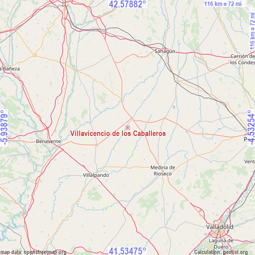
Villavicencio de los Caballeros GPS coordinates[2]
42° 3' 32.148" North, 5° 14' 8.376" West
| Map corner | latitude | longitude |
|---|---|---|
| Upper-left | 42.57882°, | -5.93879° |
| Center: | 42.05893°, | -5.23566° |
| Lower-right: | 41.53475°, | -4.53254° |
| Map W x H: | 116.1×116.1 km | = 72.1×72.1mi |
| max Lat: | 43.74134° ⇑24.7% North |
| Villavicencio de los Caballeros: | 42.05893° |
| min Lat: | ⇓75.3% South 27.64134° |
| min Long | Villavicencio d | max Long |
| -18.00367° | -5.23566° | 4.2899° |
| W 24.4%⇐ | ⇒75.6% E |
Elevation
Elevation of Villavicencio de los Caballeros is 724 m = 2375 ft, and this is 126 m = 413 ft above average elevation for this country.
| Max E: |
1682 m = 5518 ft | 42.9% |
| Villavicencio de los Caballeros | 724 m 2375 ft | |
| Avg. | 598 m = 1962 ft | |
Min E: |
0 m = 0 ft | 57.1% |
See also: Spain elevation on elevation.city.
Geographical zone
Villavicencio de los Caballeros is located in North temperate zone (between Tropic of Cancer and the Arctic Circle). Distance of this Northern Tropic circle is 2070.6 km =1286.6 mi to South.| Distance of | km | miles | from Villavicencio de los Caballeros |
|---|---|---|---|
| North Pole | 5330.5 | 3312.2 | to North |
| Arctic Circle | 2724.7 | 1693 | to North |
| Tropic Cancer | 2070.6 | 1286.6 | to South |
| Equator | 4676.5 | 2905.8 | to South |


Nearby cities:
15 places around Villavicencio de los Caballeros: (largest is in red/bold)
• Aguilar de Campos
9.5 km =5.9 mi,  151°
151°
• Barcial de la Loma
12.6 km =7.8 mi,  198°
198°
• Becilla de Valderaduey
4.7 km =2.9 mi,  18°
18°
• Bolaños de Campos
7.1 km =4.4 mi,  214°
214°
• Castrobol
10.8 km =6.7 mi,  323°
323°
• Castroponce
8.7 km =5.4 mi,  30°
30°
• Castroverde de Campos
11.8 km =7.3 mi, 213°
• Ceinos de Campos
7.6 km =4.7 mi,  112°
112°
• Mayorga
12.2 km =7.6 mi,  349°
349°
• Urones de Castroponce
5.9 km =3.7 mi, 319°
• Valdunquillo
6.7 km =4.2 mi,  253°
253°
• Villacid de Campos
9.5 km =5.9 mi,  73°
73°
• Villagómez la Nueva
13.3 km =8.3 mi,  35°
35°
• Villalán de Campos
4.9 km =3 mi,  180°
180°
• Villamuriel de Campos
12.7 km =7.9 mi,  169°
169°
Sources, notices
• [Note1] Compared only with cities in Spain existing in our database
• [Src1] Map data: © OpenStreetMap contributors (CC-BY-SA)
• [Src2] Other city data from geonames.org with taken over terms of usage.
• [Src3] Geographical zone / Annual Mean Temperature by Robert A. Rohde @ Wikipedia
