Villabona geodata
Villabona (Basque Country) is a seat of a third-order administrative division; located in Spain in Europe/Madrid (GMT+2) time zone. With population of 5,822 people, there are 1158 cities with bigger population in this country. Compared to other cities in Spain, 96.3% of cities are located further ↓South; 66.8% of cities are located further ←West and 90.4% of cities have higher elevation than Villabona. Note1


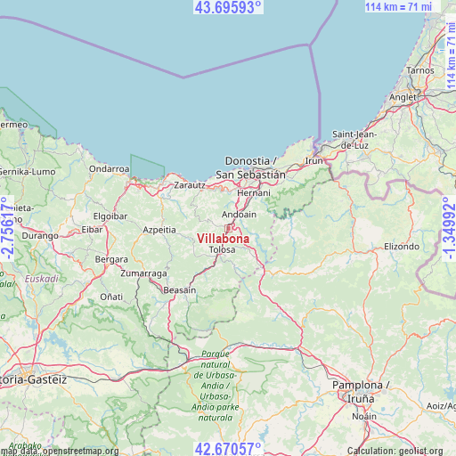
Villabona GPS coordinates[2]
43° 11' 7.44" North, 2° 3' 10.944" West
| Map corner | latitude | longitude |
|---|---|---|
| Upper-left | 43.69593°, | -2.75617° |
| Center: | 43.1854°, | -2.05304° |
| Lower-right: | 42.67057°, | -1.34992° |
| Map W x H: | 114×114 km | = 70.8×70.8mi |
| max Lat: | 43.74134° ⇑3.7% North |
| Villabona: | 43.1854° |
| min Lat: | ⇓96.3% South 27.64134° |
| min Long | Villabona | max Long |
| -18.00367° | -2.05304° | 4.2899° |
| W 66.8%⇐ | ⇒33.2% E |
Elevation
Elevation of Villabona is 59 m = 194 ft, and this is 539 m = 1768 ft below average elevation for this country.
| Max E: |
1682 m = 5518 ft | 90.4% |
| Avg. | 598 m = 1962 ft | |
| Villabona | 59 m = 194 ft | |
Min E: |
0 m = 0 ft | 9.6% |
See also: Spain elevation on elevation.city.
Geographical zone
Villabona is located in North temperate zone (between Tropic of Cancer and the Arctic Circle). Distance of this Northern Tropic circle is 2195.8 km =1364.4 mi to South.| Distance of | km | miles | from Villabona |
|---|---|---|---|
| North Pole | 5205.3 | 3234.4 | to North |
| Arctic Circle | 2599.4 | 1615.2 | to North |
| Tropic Cancer | 2195.8 | 1364.4 | to South |
| Equator | 4801.8 | 2983.7 | to South |


Nearby cities:
15 places around Villabona: (largest is in red/bold)
• Aduna
2.1 km =1.3 mi,  6°
6°
• Alkiza
4.8 km =3 mi,  252°
252°
• Andoain
4.1 km =2.5 mi,  32°
32°
• Anoeta
2.9 km =1.8 mi,  209°
209°
• Asteasu
3.8 km =2.4 mi,  285°
285°
• Belauntza
5.5 km =3.4 mi,  178°
178°
• Berrobi
5 km =3.1 mi,  154°
154°
• Elduain
6.6 km =4.1 mi,  140°
140°
• Hernialde
4.3 km =2.7 mi,  217°
217°
• Ibarra
6.1 km =3.8 mi,  189°
189°
• Irura
2.4 km =1.5 mi, 209°
• Larraul
4 km =2.5 mi,  273°
273°
• Leaburu
7.1 km =4.4 mi, 180°
• Tolosa
6 km =3.7 mi,  199°
199°
• Zizurkil
2.3 km =1.4 mi,  311°
311°
Sources, notices
• [Note1] Compared only with cities in Spain existing in our database
• [Src1] Map data: © OpenStreetMap contributors (CC-BY-SA)
• [Src2] Other city data from geonames.org with taken over terms of usage.
• [Src3] Geographical zone / Annual Mean Temperature by Robert A. Rohde @ Wikipedia
