Vertavillo geodata
Vertavillo (Castille and León) is a seat of a third-order administrative division; located in Spain in Europe/Madrid (GMT+2) time zone. With population of 214 people, there are 4955 cities with bigger population in this country. Compared to other cities in Spain, 69.4% of cities are located further ↓South; 64.1% of cities are located further →East and 70.4% of cities have lower elevation than Vertavillo. Note1
Administrative division(s):
- Level 1: Castille and León
- Level 2: Provincia de Palencia
- Level 3: Vertavillo


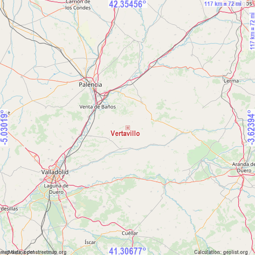
Vertavillo GPS coordinates[2]
41° 49' 58.116" North, 4° 19' 37.452" West
| Map corner | latitude | longitude |
|---|---|---|
| Upper-left | 42.35456°, | -5.03019° |
| Center: | 41.83281°, | -4.32707° |
| Lower-right: | 41.30677°, | -3.62394° |
| Map W x H: | 116.5×116.5 km | = 72.4×72.4mi |
| max Lat: | 43.74134° ⇑30.6% North |
| Vertavillo: | 41.83281° |
| min Lat: | ⇓69.4% South 27.64134° |
| min Long | Vertavillo | max Long |
| -18.00367° | -4.32707° | 4.2899° |
| W 35.9%⇐ | ⇒64.1% E |
Elevation
Elevation of Vertavillo is 817 m = 2680 ft, and this is 219 m = 719 ft above average elevation for this country.
| Max E: |
1682 m = 5518 ft | 29.6% |
| Vertavillo | 817 m 2680 ft | |
| Avg. | 598 m = 1962 ft | |
Min E: |
0 m = 0 ft | 70.4% |
See also: Spain elevation on elevation.city.
Geographical zone
Vertavillo is located in North temperate zone (between Tropic of Cancer and the Arctic Circle). Distance of this Northern Tropic circle is 2045.5 km =1271 mi to South.| Distance of | km | miles | from Vertavillo |
|---|---|---|---|
| North Pole | 5355.7 | 3327.9 | to North |
| Arctic Circle | 2749.8 | 1708.6 | to North |
| Tropic Cancer | 2045.5 | 1271 | to South |
| Equator | 4651.4 | 2890.2 | to South |


Nearby cities:
15 places around Vertavillo: (largest is in red/bold)
• Alba de Cerrato
3.8 km =2.4 mi,  234°
234°
• Amusquillo
9.6 km =6 mi,  167°
167°
• Castrillo de Onielo
3.5 km =2.2 mi,  37°
37°
• Castroverde de Cerrato
12.2 km =7.6 mi,  134°
134°
• Cevico Navero
12.2 km =7.6 mi,  75°
75°
• Cevico de la Torre
7.1 km =4.4 mi,  286°
286°
• Cubillas de Cerrato
12.2 km =7.6 mi,  251°
251°
• Esguevillas de Esgueva
10.2 km =6.3 mi,  205°
205°
• Hérmedes de Cerrato
12.8 km =8 mi,  96°
96°
• Población de Cerrato
9.5 km =5.9 mi,  242°
242°
• Torre de Esgueva
12.7 km =7.9 mi,  124°
124°
• Valle de Cerrato
6.1 km =3.8 mi,  331°
331°
• Villaco
11.4 km =7.1 mi,  154°
154°
• Villaconancio
9.6 km =6 mi,  63°
63°
• Villafuerte
11 km =6.8 mi,  178°
178°
Sources, notices
• [Note1] Compared only with cities in Spain existing in our database
• [Src1] Map data: © OpenStreetMap contributors (CC-BY-SA)
• [Src2] Other city data from geonames.org with taken over terms of usage.
• [Src3] Geographical zone / Annual Mean Temperature by Robert A. Rohde @ Wikipedia
