Villafuerte geodata
Villafuerte (Castille and León) is a seat of a third-order administrative division; located in Spain in Europe/Madrid (GMT+2) time zone. With population of 145 people, there are 5463 cities with bigger population in this country. Compared to other cities in Spain, 66.9% of cities are located further ↓South; 64.1% of cities are located further →East and 71.3% of cities have lower elevation than Villafuerte. Note1
Administrative division(s):
- Level 1: Castille and León
- Level 2: Provincia de Valladolid
- Level 3: Villafuerte


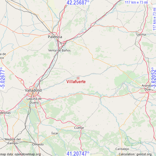
Villafuerte GPS coordinates[2]
41° 44' 3.516" North, 4° 19' 25.14" West
| Map corner | latitude | longitude |
|---|---|---|
| Upper-left | 42.25687°, | -5.02677° |
| Center: | 41.73431°, | -4.32365° |
| Lower-right: | 41.20747°, | -3.62052° |
| Map W x H: | 116.7×116.7 km | = 72.5×72.5mi |
| max Lat: | 43.74134° ⇑33.1% North |
| Villafuerte: | 41.73431° |
| min Lat: | ⇓66.9% South 27.64134° |
| min Long | Villafuerte | max Long |
| -18.00367° | -4.32365° | 4.2899° |
| W 35.9%⇐ | ⇒64.1% E |
Elevation
Elevation of Villafuerte is 823 m = 2700 ft, and this is 225 m = 738 ft above average elevation for this country.
| Max E: |
1682 m = 5518 ft | 28.7% |
| Villafuerte | 823 m 2700 ft | |
| Avg. | 598 m = 1962 ft | |
Min E: |
0 m = 0 ft | 71.3% |
See also: Spain elevation on elevation.city.
Geographical zone
Villafuerte is located in North temperate zone (between Tropic of Cancer and the Arctic Circle). Distance of this Northern Tropic circle is 2034.5 km =1264.2 mi to South.| Distance of | km | miles | from Villafuerte |
|---|---|---|---|
| North Pole | 5366.6 | 3334.6 | to North |
| Arctic Circle | 2760.8 | 1715.5 | to North |
| Tropic Cancer | 2034.5 | 1264.2 | to South |
| Equator | 4640.4 | 2883.4 | to South |


Nearby cities:
15 places around Villafuerte: (largest is in red/bold)
• Alba de Cerrato
9.4 km =5.8 mi,  338°
338°
• Amusquillo
2.4 km =1.5 mi,  49°
49°
• Castrillo de Onielo
13.9 km =8.6 mi,  7°
7°
• Castrillo-Tejeriego
5.2 km =3.2 mi,  229°
229°
• Castroverde de Cerrato
8.8 km =5.5 mi,  74°
74°
• Esguevillas de Esgueva
5 km =3.1 mi,  290°
290°
• Fombellida
12.1 km =7.5 mi, 72°
• Olivares de Duero
11.3 km =7 mi,  197°
197°
• Piña de Esgueva
8.7 km =5.4 mi,  265°
265°
• Población de Cerrato
10.9 km =6.8 mi,  306°
306°
• Quintanilla de Onésimo
12.6 km =7.8 mi, 195°
• Torre de Esgueva
10.9 km =6.8 mi, 69°
• Valbuena de Duero
10.4 km =6.5 mi,  165°
165°
• Vertavillo
11 km =6.8 mi,  358°
358°
• Villaco
4.6 km =2.9 mi,  81°
81°
Sources, notices
• [Note1] Compared only with cities in Spain existing in our database
• [Src1] Map data: © OpenStreetMap contributors (CC-BY-SA)
• [Src2] Other city data from geonames.org with taken over terms of usage.
• [Src3] Geographical zone / Annual Mean Temperature by Robert A. Rohde @ Wikipedia
