Utrillas geodata
Utrillas (Aragon) is a seat of a third-order administrative division; located in Spain in Europe/Madrid (GMT+2) time zone. With population of 3,219 people, there are 1655 cities with bigger population in this country. Compared to other cities in Spain, 55.9% of cities are located further ↑North; 78.4% of cities are located further ←West and 85% of cities have lower elevation than Utrillas. Note1


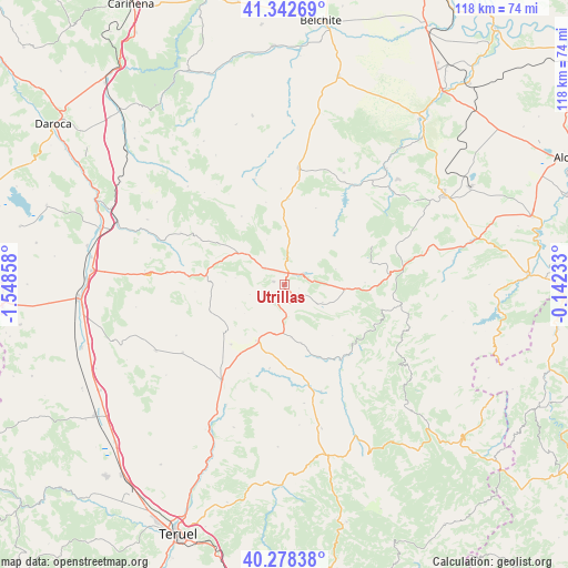
Utrillas GPS coordinates[2]
40° 48' 45.612" North, 0° 50' 43.62" West
| Map corner | latitude | longitude |
|---|---|---|
| Upper-left | 41.34269°, | -1.54858° |
| Center: | 40.81267°, | -0.84545° |
| Lower-right: | 40.27838°, | -0.14233° |
| Map W x H: | 118.3×118.3 km | = 73.5×73.5mi |
| max Lat: | 43.74134° ⇑55.9% North |
| Utrillas: | 40.81267° |
| min Lat: | ⇓44.1% South 27.64134° |
| min Long | Utrillas | max Long |
| -18.00367° | -0.84545° | 4.2899° |
| W 78.4%⇐ | ⇒21.6% E |
Elevation
Elevation of Utrillas is 951 m = 3120 ft, and this is 353 m = 1158 ft above average elevation for this country.
| Max E: |
1682 m = 5518 ft | 15% |
| Utrillas | 951 m 3120 ft | |
| Avg. | 598 m = 1962 ft | |
Min E: |
0 m = 0 ft | 85% |
See also: Spain elevation on elevation.city.
Geographical zone
Utrillas is located in North temperate zone (between Tropic of Cancer and the Arctic Circle). Distance of this Northern Tropic circle is 1932 km =1200.5 mi to South.| Distance of | km | miles | from Utrillas |
|---|---|---|---|
| North Pole | 5469.1 | 3398.3 | to North |
| Arctic Circle | 2863.2 | 1779.1 | to North |
| Tropic Cancer | 1932 | 1200.5 | to South |
| Equator | 4537.9 | 2819.7 | to South |


Nearby cities:
15 places around Utrillas: (largest is in red/bold)
• Castel de Cabra
12.6 km =7.8 mi,  95°
95°
• Cañada Vellida
13 km =8.1 mi,  206°
206°
• Cuevas de Almudén
11.1 km =6.9 mi,  173°
173°
• Escucha
3.6 km =2.2 mi,  123°
123°
• Fuenferrada
15.3 km =9.5 mi,  294°
294°
• Fuentes Calientes
16.2 km =10.1 mi,  219°
219°
• Hinojosa de Jarque
14.5 km =9 mi,  159°
159°
• Jarque de la Val
12.8 km =8 mi, 162°
• Martín del Río
5.5 km =3.4 mi,  310°
310°
• Mezquita de Jarque
10.4 km =6.5 mi,  190°
190°
• Montalbán
4.3 km =2.7 mi,  58°
58°
• Obón
14.5 km =9 mi,  45°
45°
• Palomar de Arroyos
8.8 km =5.5 mi, 115°
• Torre de las Arcas
11.2 km =7 mi,  73°
73°
• Vivel del Río Martín
10.2 km =6.3 mi, 309°
Sources, notices
• [Note1] Compared only with cities in Spain existing in our database
• [Src1] Map data: © OpenStreetMap contributors (CC-BY-SA)
• [Src2] Other city data from geonames.org with taken over terms of usage.
• [Src3] Geographical zone / Annual Mean Temperature by Robert A. Rohde @ Wikipedia
