Cuevas de Almudén geodata
Cuevas de Almudén (Aragon) is a seat of a third-order administrative division; located in Spain in Europe/Madrid (GMT+2) time zone. With population of 123 people, there are 5663 cities with bigger population in this country. Compared to other cities in Spain, 57.8% of cities are located further ↑North; 78.5% of cities are located further ←West and 98.4% of cities have lower elevation than Cuevas de Almudén. Note1


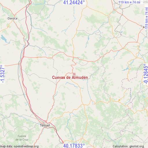
Cuevas de Almudén GPS coordinates[2]
40° 42' 48.312" North, 0° 49' 46.488" West
| Map corner | latitude | longitude |
|---|---|---|
| Upper-left | 41.24424°, | -1.5327° |
| Center: | 40.71342°, | -0.82958° |
| Lower-right: | 40.17833°, | -0.12645° |
| Map W x H: | 118.5×118.5 km | = 73.6×73.6mi |
| max Lat: | 43.74134° ⇑57.8% North |
| Cuevas de Almudén: | 40.71342° |
| min Lat: | ⇓42.2% South 27.64134° |
| min Long | Cuevas de Almud | max Long |
| -18.00367° | -0.82958° | 4.2899° |
| W 78.5%⇐ | ⇒21.5% E |
Elevation
Elevation of Cuevas de Almudén is 1285 m = 4216 ft, and this is 687 m = 2254 ft above average elevation for this country.
| Max E: |
1682 m = 5518 ft | 1.6% |
| Cuevas de Almudén | 1285 m 4216 ft | |
| Avg. | 598 m = 1962 ft | |
Min E: |
0 m = 0 ft | 98.4% |
See also: Spain elevation on elevation.city.
Geographical zone
Cuevas de Almudén is located in North temperate zone (between Tropic of Cancer and the Arctic Circle). Distance of this Northern Tropic circle is 1921 km =1193.7 mi to South.| Distance of | km | miles | from Cuevas de Almudén |
|---|---|---|---|
| North Pole | 5480.2 | 3405.2 | to North |
| Arctic Circle | 2874.3 | 1786 | to North |
| Tropic Cancer | 1921 | 1193.7 | to South |
| Equator | 4526.9 | 2812.9 | to South |


Nearby cities:
15 places around Cuevas de Almudén: (largest is in red/bold)
• Aguilar del Alfambra
14 km =8.7 mi,  168°
168°
• Aliaga
11.5 km =7.1 mi,  112°
112°
• Camarillas
12.9 km =8 mi,  150°
150°
• Castel de Cabra
15 km =9.3 mi,  48°
48°
• Cañada Vellida
7.2 km =4.5 mi,  265°
265°
• Escucha
9.2 km =5.7 mi,  10°
10°
• Fuentes Calientes
11.7 km =7.3 mi,  262°
262°
• Galve
7.8 km =4.8 mi,  214°
214°
• Hinojosa de Jarque
4.5 km =2.8 mi,  124°
124°
• Jarque de la Val
2.7 km =1.7 mi, 115°
• Mezquita de Jarque
3.3 km =2.1 mi,  284°
284°
• Montalbán
13.5 km =8.4 mi, 10°
• Palomar de Arroyos
9.9 km =6.2 mi,  42°
42°
• Rillo
14.1 km =8.8 mi, 274°
• Utrillas
11.1 km =6.9 mi,  353°
353°
Sources, notices
• [Note1] Compared only with cities in Spain existing in our database
• [Src1] Map data: © OpenStreetMap contributors (CC-BY-SA)
• [Src2] Other city data from geonames.org with taken over terms of usage.
• [Src3] Geographical zone / Annual Mean Temperature by Robert A. Rohde @ Wikipedia
