Uña de Quintana geodata
Uña de Quintana (Castille and León) is a seat of a third-order administrative division; located in Spain in Europe/Madrid (GMT+2) time zone. With population of 210 people, there are 4985 cities with bigger population in this country. Compared to other cities in Spain, 76.2% of cities are located further ↓South; 87.9% of cities are located further →East and 65.8% of cities have lower elevation than Uña de Quintana. Note1
Administrative division(s):
- Level 1: Castille and León
- Level 2: Provincia de Zamora
- Level 3: Uña de Quintana


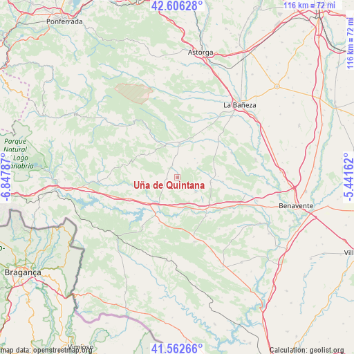
Uña de Quintana GPS coordinates[2]
42° 5' 11.832" North, 6° 8' 41.1" West
| Map corner | latitude | longitude |
|---|---|---|
| Upper-left | 42.60628°, | -6.84787° |
| Center: | 42.08662°, | -6.14475° |
| Lower-right: | 41.56266°, | -5.44162° |
| Map W x H: | 116×116 km | = 72.1×72.1mi |
| max Lat: | 43.74134° ⇑23.8% North |
| Uña de Quintana: | 42.08662° |
| min Lat: | ⇓76.2% South 27.64134° |
| min Long | Uña de Quintan | max Long |
| -18.00367° | -6.14475° | 4.2899° |
| W 12.1%⇐ | ⇒87.9% E |
Elevation
Elevation of Uña de Quintana is 783 m = 2569 ft, and this is 185 m = 607 ft above average elevation for this country.
| Max E: |
1682 m = 5518 ft | 34.2% |
| Uña de Quintana | 783 m 2569 ft | |
| Avg. | 598 m = 1962 ft | |
Min E: |
0 m = 0 ft | 65.8% |
See also: Spain elevation on elevation.city.
Geographical zone
Uña de Quintana is located in North temperate zone (between Tropic of Cancer and the Arctic Circle). Distance of this Northern Tropic circle is 2073.7 km =1288.5 mi to South.| Distance of | km | miles | from Uña de Quintana |
|---|---|---|---|
| North Pole | 5327.5 | 3310.4 | to North |
| Arctic Circle | 2721.6 | 1691.1 | to North |
| Tropic Cancer | 2073.7 | 1288.5 | to South |
| Equator | 4679.6 | 2907.8 | to South |


Nearby cities:
15 places around Uña de Quintana: (largest is in red/bold)
• Ayoó de Vidriales
8.2 km =5.1 mi,  53°
53°
• Brime de Sog
8.5 km =5.3 mi,  109°
109°
• Calzadilla de Tera
13 km =8.1 mi,  156°
156°
• Camarzana de Tera
14.1 km =8.8 mi,  136°
136°
• Castrocontrigo
11.4 km =7.1 mi,  340°
340°
• Cubo de Benavente
4.5 km =2.8 mi, 340°
• Fuente Encalada
12.5 km =7.8 mi,  77°
77°
• Justel
14.2 km =8.8 mi,  298°
298°
• Molezuelas de la Carballeda
3.5 km =2.2 mi,  261°
261°
• Otero de Bodas
16.5 km =10.3 mi,  181°
181°
• Peque
10.8 km =6.7 mi, 261°
• San Pedro de Ceque
7.7 km =4.8 mi,  128°
128°
• Santibáñez de Vidriales
10.8 km =6.7 mi,  97°
97°
• Vega de Tera
10 km =6.2 mi,  170°
170°
• Villageriz
16 km =9.9 mi, 77°
Sources, notices
• [Note1] Compared only with cities in Spain existing in our database
• [Src1] Map data: © OpenStreetMap contributors (CC-BY-SA)
• [Src2] Other city data from geonames.org with taken over terms of usage.
• [Src3] Geographical zone / Annual Mean Temperature by Robert A. Rohde @ Wikipedia
