Peque geodata
Peque (Castille and León) is a seat of a third-order administrative division; located in Spain in Europe/Madrid (GMT+2) time zone. With population of 171 people, there are 5259 cities with bigger population in this country. Compared to other cities in Spain, 75.8% of cities are located further ↓South; 89.2% of cities are located further →East and 75.2% of cities have lower elevation than Peque. Note1


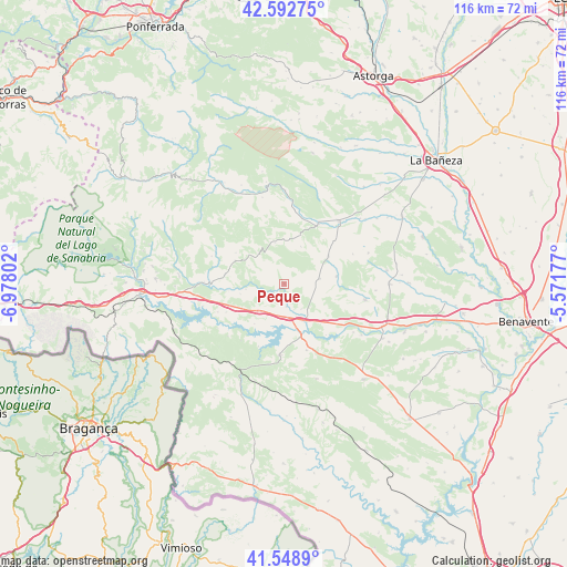
Peque GPS coordinates[2]
42° 4' 22.692" North, 6° 16' 29.604" West
| Map corner | latitude | longitude |
|---|---|---|
| Upper-left | 42.59275°, | -6.97802° |
| Center: | 42.07297°, | -6.27489° |
| Lower-right: | 41.5489°, | -5.57177° |
| Map W x H: | 116.1×116.1 km | = 72.1×72.1mi |
| max Lat: | 43.74134° ⇑24.2% North |
| Peque: | 42.07297° |
| min Lat: | ⇓75.8% South 27.64134° |
| min Long | Peque | max Long |
| -18.00367° | -6.27489° | 4.2899° |
| W 10.8%⇐ | ⇒89.2% E |
Elevation
Elevation of Peque is 853 m = 2799 ft, and this is 255 m = 837 ft above average elevation for this country.
| Max E: |
1682 m = 5518 ft | 24.8% |
| Peque | 853 m 2799 ft | |
| Avg. | 598 m = 1962 ft | |
Min E: |
0 m = 0 ft | 75.2% |
See also: Spain elevation on elevation.city.
Geographical zone
Peque is located in North temperate zone (between Tropic of Cancer and the Arctic Circle). Distance of this Northern Tropic circle is 2072.2 km =1287.6 mi to South.| Distance of | km | miles | from Peque |
|---|---|---|---|
| North Pole | 5329 | 3311.3 | to North |
| Arctic Circle | 2723.1 | 1692.1 | to North |
| Tropic Cancer | 2072.2 | 1287.6 | to South |
| Equator | 4678.1 | 2906.8 | to South |


Nearby cities:
15 places around Peque: (largest is in red/bold)
• Asturianos
17.9 km =11.1 mi,  262°
262°
• Castrocontrigo
14.1 km =8.8 mi,  29°
29°
• Cernadilla
13.1 km =8.1 mi,  243°
243°
• Cubo de Benavente
10.9 km =6.8 mi,  57°
57°
• Espadañedo
11 km =6.8 mi,  296°
296°
• Justel
8.6 km =5.3 mi,  348°
348°
• Manzanal de Arriba
16.3 km =10.1 mi, 236°
• Manzanal de los Infantes
9.2 km =5.7 mi, 256°
• Molezuelas de la Carballeda
7.3 km =4.5 mi,  82°
82°
• Mombuey
7.2 km =4.5 mi,  219°
219°
• Muelas de los Caballeros
8 km =5 mi,  320°
320°
• San Pedro de Ceque
17 km =10.6 mi,  101°
101°
• Uña de Quintana
10.8 km =6.7 mi, 81°
• Vega de Tera
14.9 km =9.3 mi,  124°
124°
• Villardeciervos
14.6 km =9.1 mi,  183°
183°
Sources, notices
• [Note1] Compared only with cities in Spain existing in our database
• [Src1] Map data: © OpenStreetMap contributors (CC-BY-SA)
• [Src2] Other city data from geonames.org with taken over terms of usage.
• [Src3] Geographical zone / Annual Mean Temperature by Robert A. Rohde @ Wikipedia
