Topas geodata
Topas (Castille and León) is a seat of a third-order administrative division; located in Spain in Europe/Madrid (GMT+2) time zone. With population of 681 people, there are 3433 cities with bigger population in this country. Compared to other cities in Spain, 52.2% of cities are located further ↓South; 80.6% of cities are located further →East and 71.6% of cities have lower elevation than Topas. Note1
Administrative division(s):
- Level 1: Castille and León
- Level 2: Provincia de Salamanca
- Level 3: Topas


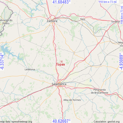
Topas GPS coordinates[2]
41° 9' 27.324" North, 5° 38' 2.472" West
| Map corner | latitude | longitude |
|---|---|---|
| Upper-left | 41.68483°, | -6.33714° |
| Center: | 41.15759°, | -5.63402° |
| Lower-right: | 40.62607°, | -4.93089° |
| Map W x H: | 117.7×117.7 km | = 73.1×73.1mi |
| max Lat: | 43.74134° ⇑47.8% North |
| Topas: | 41.15759° |
| min Lat: | ⇓52.2% South 27.64134° |
| min Long | Topas | max Long |
| -18.00367° | -5.63402° | 4.2899° |
| W 19.4%⇐ | ⇒80.6% E |
Elevation
Elevation of Topas is 825 m = 2707 ft, and this is 227 m = 745 ft above average elevation for this country.
| Max E: |
1682 m = 5518 ft | 28.4% |
| Topas | 825 m 2707 ft | |
| Avg. | 598 m = 1962 ft | |
Min E: |
0 m = 0 ft | 71.6% |
See also: Spain elevation on elevation.city.
Geographical zone
Topas is located in North temperate zone (between Tropic of Cancer and the Arctic Circle). Distance of this Northern Tropic circle is 1970.4 km =1224.3 mi to South.| Distance of | km | miles | from Topas |
|---|---|---|---|
| North Pole | 5430.8 | 3374.5 | to North |
| Arctic Circle | 2824.9 | 1755.3 | to North |
| Tropic Cancer | 1970.4 | 1224.3 | to South |
| Equator | 4576.3 | 2843.6 | to South |


Nearby cities:
15 places around Topas: (largest is in red/bold)
• Aldeanueva de Figueroa
9.3 km =5.8 mi,  96°
96°
• Arcediano
9.4 km =5.8 mi,  139°
139°
• Calzada de Valdunciel
9.7 km =6 mi,  215°
215°
• Castellanos de Villiquera
12.9 km =8 mi,  203°
203°
• Forfoleda
11.8 km =7.3 mi,  235°
235°
• Fuentesaúco
14 km =8.7 mi,  54°
54°
• Negrilla de Palencia
8.1 km =5 mi,  154°
154°
• Pajares de la Laguna
13.1 km =8.1 mi,  126°
126°
• Palencia de Negrilla
7.5 km =4.7 mi,  158°
158°
• Pedrosillo el Ralo
12.7 km =7.9 mi, 145°
• Tardáguila
6.9 km =4.3 mi, 133°
• Valdelosa
12.6 km =7.8 mi,  277°
277°
• Valdunciel
8.6 km =5.3 mi, 201°
• Villamor de los Escuderos
11.7 km =7.3 mi,  25°
25°
• Villaverde de Guareña
13.8 km =8.6 mi, 138°
Sources, notices
• [Note1] Compared only with cities in Spain existing in our database
• [Src1] Map data: © OpenStreetMap contributors (CC-BY-SA)
• [Src2] Other city data from geonames.org with taken over terms of usage.
• [Src3] Geographical zone / Annual Mean Temperature by Robert A. Rohde @ Wikipedia
