Tajahuerce geodata
Tajahuerce (Castille and León) is a seat of a third-order administrative division; located in Spain in Europe/Madrid (GMT+2) time zone. With population of 37 people, there are 6601 cities with bigger population in this country. Compared to other cities in Spain, 67.1% of cities are located further ↓South; 65.4% of cities are located further ←West and 91.5% of cities have lower elevation than Tajahuerce. Note1
Administrative division(s):
- Level 1: Castille and León
- Level 2: Provincia de Soria
- Level 3: Tajahuerce


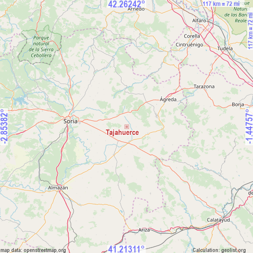
Tajahuerce GPS coordinates[2]
41° 44' 23.676" North, 2° 9' 2.484" West
| Map corner | latitude | longitude |
|---|---|---|
| Upper-left | 42.26242°, | -2.85382° |
| Center: | 41.73991°, | -2.15069° |
| Lower-right: | 41.21311°, | -1.44757° |
| Map W x H: | 116.7×116.7 km | = 72.5×72.5mi |
| max Lat: | 43.74134° ⇑32.9% North |
| Tajahuerce: | 41.73991° |
| min Lat: | ⇓67.1% South 27.64134° |
| min Long | Tajahuerce | max Long |
| -18.00367° | -2.15069° | 4.2899° |
| W 65.4%⇐ | ⇒34.6% E |
Elevation
Elevation of Tajahuerce is 1057 m = 3468 ft, and this is 459 m = 1506 ft above average elevation for this country.
| Max E: |
1682 m = 5518 ft | 8.5% |
| Tajahuerce | 1057 m 3468 ft | |
| Avg. | 598 m = 1962 ft | |
Min E: |
0 m = 0 ft | 91.5% |
See also: Spain elevation on elevation.city.
Geographical zone
Tajahuerce is located in North temperate zone (between Tropic of Cancer and the Arctic Circle). Distance of this Northern Tropic circle is 2035.1 km =1264.6 mi to South.| Distance of | km | miles | from Tajahuerce |
|---|---|---|---|
| North Pole | 5366 | 3334.3 | to North |
| Arctic Circle | 2760.1 | 1715 | to North |
| Tropic Cancer | 2035.1 | 1264.6 | to South |
| Equator | 4641 | 2883.8 | to South |


Nearby cities:
15 places around Tajahuerce: (largest is in red/bold)
• Aldealpozo
6.5 km =4 mi,  316°
316°
• Aliud
12.8 km =8 mi,  221°
221°
• Almenar de Soria
7.6 km =4.7 mi,  213°
213°
• Arancón
12.7 km =7.9 mi,  301°
301°
• Buberos
10.9 km =6.8 mi,  199°
199°
• Cabrejas del Campo
11.9 km =7.4 mi,  236°
236°
• Candilichera
13.1 km =8.1 mi,  252°
252°
• Hinojosa del Campo
4.3 km =2.7 mi,  92°
92°
• Noviercas
10.1 km =6.3 mi,  107°
107°
• Pinilla del Campo
6.1 km =3.8 mi, 114°
• Portillo de Soria
11.9 km =7.4 mi,  168°
168°
• Pozalmuro
5.6 km =3.5 mi,  46°
46°
• Torrubia de Soria
13.1 km =8.1 mi,  158°
158°
• Villar del Campo
5.4 km =3.4 mi,  0°
0°
• Villaseca de Arciel
12.9 km =8 mi,  184°
184°
Sources, notices
• [Note1] Compared only with cities in Spain existing in our database
• [Src1] Map data: © OpenStreetMap contributors (CC-BY-SA)
• [Src2] Other city data from geonames.org with taken over terms of usage.
• [Src3] Geographical zone / Annual Mean Temperature by Robert A. Rohde @ Wikipedia
