Aliud geodata
Aliud (Castille and León) is a seat of a third-order administrative division; located in Spain in Europe/Madrid (GMT+2) time zone. With population of 31 people, there are 6654 cities with bigger population in this country. Compared to other cities in Spain, 64.9% of cities are located further ↓South; 64.1% of cities are located further ←West and 88.8% of cities have lower elevation than Aliud. Note1


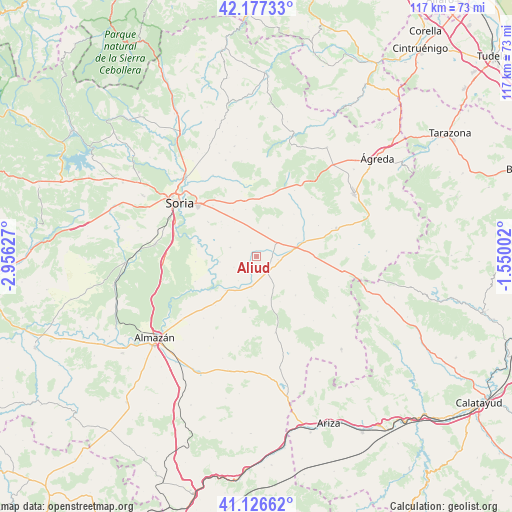
Aliud GPS coordinates[2]
41° 39' 14.832" North, 2° 15' 11.304" West
| Map corner | latitude | longitude |
|---|---|---|
| Upper-left | 42.17733°, | -2.95627° |
| Center: | 41.65412°, | -2.25314° |
| Lower-right: | 41.12662°, | -1.55002° |
| Map W x H: | 116.8×116.8 km | = 72.6×72.6mi |
| max Lat: | 43.74134° ⇑35.1% North |
| Aliud: | 41.65412° |
| min Lat: | ⇓64.9% South 27.64134° |
| min Long | Aliud | max Long |
| -18.00367° | -2.25314° | 4.2899° |
| W 64.1%⇐ | ⇒35.9% E |
Elevation
Elevation of Aliud is 1011 m = 3317 ft, and this is 413 m = 1355 ft above average elevation for this country.
| Max E: |
1682 m = 5518 ft | 11.2% |
| Aliud | 1011 m 3317 ft | |
| Avg. | 598 m = 1962 ft | |
Min E: |
0 m = 0 ft | 88.8% |
See also: Spain elevation on elevation.city.
Geographical zone
Aliud is located in North temperate zone (between Tropic of Cancer and the Arctic Circle). Distance of this Northern Tropic circle is 2025.6 km =1258.6 mi to South.| Distance of | km | miles | from Aliud |
|---|---|---|---|
| North Pole | 5375.6 | 3340.2 | to North |
| Arctic Circle | 2769.7 | 1721 | to North |
| Tropic Cancer | 2025.6 | 1258.6 | to South |
| Equator | 4631.5 | 2877.9 | to South |


Nearby cities:
15 places around Aliud: (largest is in red/bold)
• Alconaba
13.4 km =8.3 mi,  305°
305°
• Aldealafuente
6.3 km =3.9 mi,  288°
288°
• Almazul
12.6 km =7.8 mi,  135°
135°
• Almenar de Soria
5.4 km =3.4 mi,  54°
54°
• Bliecos
14.1 km =8.8 mi,  186°
186°
• Borjabad
14.7 km =9.1 mi,  219°
219°
• Buberos
5 km =3.1 mi,  99°
99°
• Cabrejas del Campo
3.3 km =2.1 mi,  335°
335°
• Candilichera
6.9 km =4.3 mi,  324°
324°
• Gómara
4.1 km =2.5 mi,  145°
145°
• Portillo de Soria
11.1 km =6.9 mi, 100°
• Tajahuerce
12.8 km =8 mi,  41°
41°
• Tejado
7.3 km =4.5 mi, 189°
• Torrubia de Soria
13.7 km =8.5 mi, 101°
• Villaseca de Arciel
8.3 km =5.2 mi,  113°
113°
Sources, notices
• [Note1] Compared only with cities in Spain existing in our database
• [Src1] Map data: © OpenStreetMap contributors (CC-BY-SA)
• [Src2] Other city data from geonames.org with taken over terms of usage.
• [Src3] Geographical zone / Annual Mean Temperature by Robert A. Rohde @ Wikipedia
