Cerdanyola del Vallès geodata
Cerdanyola del Vallès (Catalonia) is a populated place; located in Spain in Europe/Madrid (GMT+2) time zone. With population of 58,747 people, there are 162 cities with bigger population in this country. Compared to other cities in Spain, 60.6% of cities are located further ↓South; 94.2% of cities are located further ←West and 88.4% of cities have higher elevation than Cerdanyola del Vallès. Note1
Administrative division(s):
- Level 1: Catalonia
- Level 2: Província de Barcelona
- Level 3: Cerdanyola del Vallès
Current local time in Cerdanyola del Vallès:
10:42 PM, ThursdayDifference from your time zone: hours


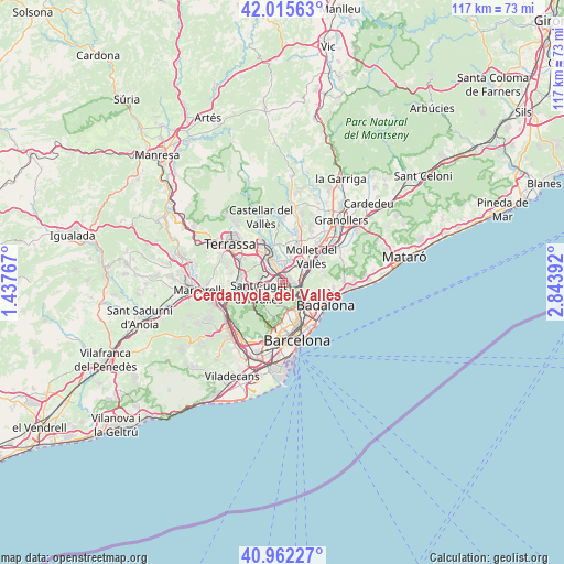
Cerdanyola del Vallès GPS coordinates[2]
41° 29' 27.924" North, 2° 8' 26.844" East
| Map corner | latitude | longitude |
|---|---|---|
| Upper-left | 42.01563°, | 1.43767° |
| Center: | 41.49109°, | 2.14079° |
| Lower-right: | 40.96227°, | 2.84392° |
| Map W x H: | 117.1×117.1 km | = 72.8×72.8mi |
| max Lat: | 43.74134° ⇑39.4% North |
| Cerdanyola del Vallès: | 41.49109° |
| min Lat: | ⇓60.6% South 27.64134° |
| min Long | Cerdanyola del | max Long |
| -18.00367° | 2.14079° | 4.2899° |
| W 94.2%⇐ | ⇒5.8% E |
Elevation
Elevation of Cerdanyola del Vallès is 88 m = 289 ft, and this is 510 m = 1673 ft below average elevation for this country.
| Max E: |
1682 m = 5518 ft | 88.4% |
| Avg. | 598 m = 1962 ft | |
| Cerdanyola del Vallès | 88 m = 289 ft | |
Min E: |
0 m = 0 ft | 11.6% |
See also: Cerdanyola del Vallès elevation on elevation.city.
Geographical zone
Cerdanyola del Vallès is located in North temperate zone (between Tropic of Cancer and the Arctic Circle). Distance of this Northern Tropic circle is 2007.5 km =1247.4 mi to South.| Distance of | km | miles | from Cerdanyola del Vallès |
|---|---|---|---|
| North Pole | 5393.7 | 3351.5 | to North |
| Arctic Circle | 2787.8 | 1732.3 | to North |
| Tropic Cancer | 2007.5 | 1247.4 | to South |
| Equator | 4613.4 | 2866.6 | to South |


Nearby cities:
15 places around Cerdanyola del Vallès: (largest is in red/bold)
• Barberà del Vallès
3.1 km =1.9 mi,  333°
333°
• Canyelles
5.5 km =3.4 mi,  159°
159°
• Ciutat Meridiana
4.4 km =2.7 mi,  139°
139°
• Horta
6.2 km =3.9 mi,  167°
167°
• La Llagosta
5.1 km =3.2 mi,  59°
59°
• Montcada i Reixac
3.6 km =2.2 mi,  103°
103°
• Ripollet
1.5 km =0.9 mi,  65°
65°
• Sant Cugat del Vallès
5.1 km =3.2 mi,  243°
243°
• Santa Perpètua de Mogoda
5.9 km =3.7 mi,  37°
37°
• Torre Baró
4.9 km =3 mi,  145°
145°
• Vallbona
4.7 km =2.9 mi,  130°
130°
• Verdun
6.1 km =3.8 mi, 151°
• la Trinitat Nova
5.8 km =3.6 mi, 140°
• la Trinitat Vella
6.2 km =3.9 mi, 135°
• les Roquetes
5.6 km =3.5 mi, 149°
Sources, notices
• [Note1] Compared only with cities in Spain existing in our database
• [Src1] Map data: © OpenStreetMap contributors (CC-BY-SA)
• [Src2] Other city data from geonames.org with taken over terms of usage.
• [Src3] Geographical zone / Annual Mean Temperature by Robert A. Rohde @ Wikipedia
