Verdun geodata
Verdun (Catalonia) is a section of populated place; located in Spain in Europe/Madrid (GMT+2) time zone. With population of 12,294 people, there are 736 cities with bigger population in this country. Compared to other cities in Spain, 59.3% of cities are located further ↓South; 94.9% of cities are located further ←West and 88.1% of cities have higher elevation than Verdun. Note1
Administrative division(s):
- Level 1: Catalonia
- Level 2: Província de Barcelona
- Level 3: Barcelona
- Level 4: Nou Barris


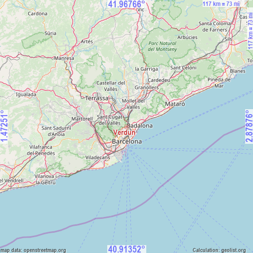
Verdun GPS coordinates[2]
41° 26' 33.828" North, 2° 10' 32.304" East
| Map corner | latitude | longitude |
|---|---|---|
| Upper-left | 41.96766°, | 1.47251° |
| Center: | 41.44273°, | 2.17564° |
| Lower-right: | 40.91352°, | 2.87876° |
| Map W x H: | 117.2×117.2 km | = 72.8×72.8mi |
| max Lat: | 43.74134° ⇑40.7% North |
| Verdun: | 41.44273° |
| min Lat: | ⇓59.3% South 27.64134° |
| min Long | Verdun | max Long |
| -18.00367° | 2.17564° | 4.2899° |
| W 94.9%⇐ | ⇒5.1% E |
Elevation
Elevation of Verdun is 93 m = 305 ft, and this is 505 m = 1657 ft below average elevation for this country.
| Max E: |
1682 m = 5518 ft | 88.1% |
| Avg. | 598 m = 1962 ft | |
| Verdun | 93 m = 305 ft | |
Min E: |
0 m = 0 ft | 11.9% |
See also: Spain elevation on elevation.city.
Geographical zone
Verdun is located in North temperate zone (between Tropic of Cancer and the Arctic Circle). Distance of this Northern Tropic circle is 2002.1 km =1244 mi to South.| Distance of | km | miles | from Verdun |
|---|---|---|---|
| North Pole | 5399.1 | 3354.8 | to North |
| Arctic Circle | 2793.2 | 1735.6 | to North |
| Tropic Cancer | 2002.1 | 1244 | to South |
| Equator | 4608 | 2863.3 | to South |


Nearby cities:
15 places around Verdun: (largest is in red/bold)
• Barri de Sant Andreu
1.4 km =0.9 mi,  117°
117°
• Can Peguera
1.2 km =0.7 mi,  221°
221°
• Canyelles
1 km =0.6 mi,  284°
284°
• Horta
1.7 km =1.1 mi,  244°
244°
• Nou Barris
0.2 km =0.1 mi,  131°
131°
• Porta
0.9 km =0.6 mi,  163°
163°
• Sant Andreu
1.4 km =0.9 mi, 124°
• Torre Baró
1.4 km =0.9 mi,  354°
354°
• Vilapicina i la Torre Llobeta
1.6 km =1 mi,  184°
184°
• el Turó de la Peira
1.3 km =0.8 mi,  205°
205°
• la Guineueta
0.7 km =0.4 mi,  232°
232°
• la Prosperitat
0.5 km =0.3 mi,  90°
90°
• la Trinitat Nova
1.2 km =0.7 mi,  41°
41°
• la Trinitat Vella
1.7 km =1.1 mi,  55°
55°
• les Roquetes
0.6 km =0.4 mi,  356°
356°
Sources, notices
• [Note1] Compared only with cities in Spain existing in our database
• [Src1] Map data: © OpenStreetMap contributors (CC-BY-SA)
• [Src2] Other city data from geonames.org with taken over terms of usage.
• [Src3] Geographical zone / Annual Mean Temperature by Robert A. Rohde @ Wikipedia
