Doneztebe geodata
Doneztebe (Navarre) is a populated place; located in Spain in Europe/Madrid (GMT+2) time zone. With population of 1,506 people, there are 2456 cities with bigger population in this country. Compared to other cities in Spain, 95.6% of cities are located further ↓South; 71.2% of cities are located further ←West and 86.1% of cities have higher elevation than Doneztebe. Note1
Administrative division(s):
- Level 1: Navarre
- Level 2: Provincia de Navarra
- Level 3: Doneztebe/Santesteban


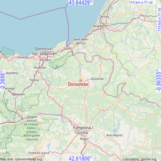
Doneztebe GPS coordinates[2]
43° 7' 59.988" North, 1° 40' 0.012" West
| Map corner | latitude | longitude |
|---|---|---|
| Upper-left | 43.64429°, | -2.3698° |
| Center: | 43.13333°, | -1.66667° |
| Lower-right: | 42.61806°, | -0.96355° |
| Map W x H: | 114.1×114.1 km | = 70.9×70.9mi |
| max Lat: | 43.74134° ⇑4.4% North |
| Doneztebe: | 43.13333° |
| min Lat: | ⇓95.6% South 27.64134° |
| min Long | Doneztebe | max Long |
| -18.00367° | -1.66667° | 4.2899° |
| W 71.2%⇐ | ⇒28.8% E |
Elevation
Elevation of Doneztebe is 122 m = 400 ft, and this is 476 m = 1562 ft below average elevation for this country.
| Max E: |
1682 m = 5518 ft | 86.1% |
| Avg. | 598 m = 1962 ft | |
| Doneztebe | 122 m = 400 ft | |
Min E: |
0 m = 0 ft | 13.9% |
See also: Spain elevation on elevation.city.
Geographical zone
Doneztebe is located in North temperate zone (between Tropic of Cancer and the Arctic Circle). Distance of this Northern Tropic circle is 2190.1 km =1360.9 mi to South.| Distance of | km | miles | from Doneztebe |
|---|---|---|---|
| North Pole | 5211.1 | 3238 | to North |
| Arctic Circle | 2605.2 | 1618.8 | to North |
| Tropic Cancer | 2190.1 | 1360.9 | to South |
| Equator | 4796 | 2980.1 | to South |


Nearby cities:
15 places around Doneztebe: (largest is in red/bold)
• Arantza
8.4 km =5.2 mi,  325°
325°
• Bera
16.6 km =10.3 mi,  354°
354°
• Elgorriaga
1.7 km =1.1 mi,  289°
289°
• Eratsun
12.2 km =7.6 mi,  242°
242°
• Etxalar
11.4 km =7.1 mi,  12°
12°
• Ezkurra
13.4 km =8.3 mi,  245°
245°
• Goizueta
16.6 km =10.3 mi,  284°
284°
• Igantzi
10.6 km =6.6 mi,  344°
344°
• Ituren
4.4 km =2.7 mi,  268°
268°
• Lantz
15.4 km =9.6 mi,  164°
164°
• Lesaka
13.3 km =8.3 mi, 348°
• Oitz
2.3 km =1.4 mi,  216°
216°
• Saldías
10.4 km =6.5 mi, 241°
• Sunbilla
3.7 km =2.3 mi,  0°
0°
• Zubieta
6.2 km =3.9 mi,  261°
261°
Sources, notices
• [Note1] Compared only with cities in Spain existing in our database
• [Src1] Map data: © OpenStreetMap contributors (CC-BY-SA)
• [Src2] Other city data from geonames.org with taken over terms of usage.
• [Src3] Geographical zone / Annual Mean Temperature by Robert A. Rohde @ Wikipedia
