Igantzi geodata
Igantzi (Navarre) is a seat of a third-order administrative division; located in Spain in Europe/Madrid (GMT+2) time zone. In our database, there are 6762 cities with bigger population. Compared to other cities in Spain, 96.6% of cities are located further ↓South; 70.6% of cities are located further ←West and 80.6% of cities have higher elevation than Igantzi. Note1


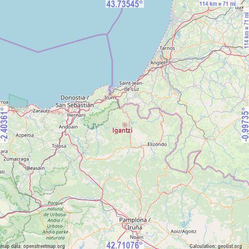
Igantzi GPS coordinates[2]
43° 13' 30.936" North, 1° 42' 1.728" West
| Map corner | latitude | longitude |
|---|---|---|
| Upper-left | 43.73545°, | -2.40361° |
| Center: | 43.22526°, | -1.70048° |
| Lower-right: | 42.71076°, | -0.99735° |
| Map W x H: | 113.9×113.9 km | = 70.8×70.8mi |
| max Lat: | 43.74134° ⇑3.4% North |
| Igantzi: | 43.22526° |
| min Lat: | ⇓96.6% South 27.64134° |
| min Long | Igantzi | max Long |
| -18.00367° | -1.70048° | 4.2899° |
| W 70.6%⇐ | ⇒29.4% E |
Elevation
Elevation of Igantzi is 209 m = 686 ft, and this is 389 m = 1276 ft below average elevation for this country.
| Max E: |
1682 m = 5518 ft | 80.6% |
| Avg. | 598 m = 1962 ft | |
| Igantzi | 209 m = 686 ft | |
Min E: |
0 m = 0 ft | 19.4% |
See also: Spain elevation on elevation.city.
Geographical zone
Igantzi is located in North temperate zone (between Tropic of Cancer and the Arctic Circle). Distance of this Northern Tropic circle is 2200.3 km =1367.2 mi to South.| Distance of | km | miles | from Igantzi |
|---|---|---|---|
| North Pole | 5200.9 | 3231.7 | to North |
| Arctic Circle | 2595 | 1612.5 | to North |
| Tropic Cancer | 2200.3 | 1367.2 | to South |
| Equator | 4806.2 | 2986.4 | to South |


Nearby cities:
15 places around Igantzi: (largest is in red/bold)
• Arano
16.1 km =10 mi,  259°
259°
• Arantza
3.8 km =2.4 mi,  211°
211°
• Bera
6.4 km =4 mi,  10°
10°
• Doneztebe
10.6 km =6.6 mi,  164°
164°
• Elgorriaga
9.7 km =6 mi,  173°
173°
• Etxalar
5.3 km =3.3 mi,  79°
79°
• Goizueta
14.5 km =9 mi,  245°
245°
• Irun
14.6 km =9.1 mi,  330°
330°
• Ituren
10.5 km =6.5 mi,  188°
188°
• Lesaka
2.8 km =1.7 mi,  0°
0°
• Oitz
12.2 km =7.6 mi, 173°
• Saldías
16.5 km =10.3 mi,  202°
202°
• Sunbilla
7.1 km =4.4 mi, 157°
• Zubieta
11.7 km =7.3 mi, 196°
• Zugarramurdi
13.8 km =8.6 mi,  69°
69°
Sources, notices
• [Note1] Compared only with cities in Spain existing in our database
• [Src1] Map data: © OpenStreetMap contributors (CC-BY-SA)
• [Src2] Other city data from geonames.org with taken over terms of usage.
• [Src3] Geographical zone / Annual Mean Temperature by Robert A. Rohde @ Wikipedia
