Sant Pol de Mar geodata
Sant Pol de Mar (Catalonia) is a seat of a third-order administrative division; located in Spain in Europe/Madrid (GMT+2) time zone. With population of 5,076 people, there are 1284 cities with bigger population in this country. Compared to other cities in Spain, 63.5% of cities are located further ↓South; 96.9% of cities are located further ←West and 94.3% of cities have higher elevation than Sant Pol de Mar. Note1
Administrative division(s):
- Level 1: Catalonia
- Level 2: Província de Barcelona
- Level 3: Sant Pol de Mar


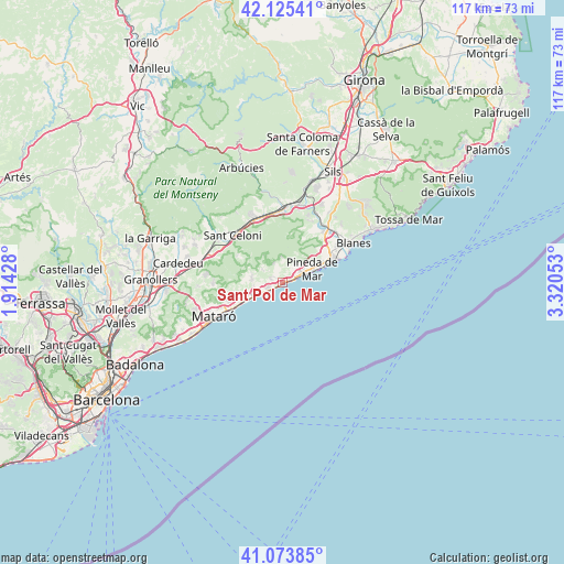
Sant Pol de Mar GPS coordinates[2]
41° 36' 6.372" North, 2° 37' 2.676" East
| Map corner | latitude | longitude |
|---|---|---|
| Upper-left | 42.12541°, | 1.91428° |
| Center: | 41.60177°, | 2.61741° |
| Lower-right: | 41.07385°, | 3.32053° |
| Map W x H: | 116.9×116.9 km | = 72.6×72.6mi |
| max Lat: | 43.74134° ⇑36.5% North |
| Sant Pol de Mar: | 41.60177° |
| min Lat: | ⇓63.5% South 27.64134° |
| min Long | Sant Pol de Mar | max Long |
| -18.00367° | 2.61741° | 4.2899° |
| W 96.9%⇐ | ⇒3.1% E |
Elevation
Elevation of Sant Pol de Mar is 29 m = 95 ft, and this is 569 m = 1867 ft below average elevation for this country.
| Max E: |
1682 m = 5518 ft | 94.3% |
| Avg. | 598 m = 1962 ft | |
| Sant Pol de Mar | 29 m = 95 ft | |
Min E: |
0 m = 0 ft | 5.7% |
See also: Spain elevation on elevation.city.
Geographical zone
Sant Pol de Mar is located in North temperate zone (between Tropic of Cancer and the Arctic Circle). Distance of this Northern Tropic circle is 2019.8 km =1255 mi to South.| Distance of | km | miles | from Sant Pol de Mar |
|---|---|---|---|
| North Pole | 5381.4 | 3343.8 | to North |
| Arctic Circle | 2775.5 | 1724.6 | to North |
| Tropic Cancer | 2019.8 | 1255 | to South |
| Equator | 4625.7 | 2874.3 | to South |


Nearby cities:
15 places around Sant Pol de Mar: (largest is in red/bold)
• Arenys de Mar
6.1 km =3.8 mi,  248°
248°
• Arenys de Munt
6.6 km =4.1 mi,  282°
282°
• Caldes d'Estrac
8 km =5 mi,  240°
240°
• Calella
3.3 km =2.1 mi,  66°
66°
• Canet de Mar
3.3 km =2.1 mi, 247°
• Malgrat de Mar
11.4 km =7.1 mi,  64°
64°
• Palafolls
13.2 km =8.2 mi, 56°
• Pineda de Mar
6.6 km =4.1 mi, 64°
• Sant Andreu de Llavaneres
11.8 km =7.3 mi, 250°
• Sant Celoni
14.4 km =8.9 mi,  312°
312°
• Sant Iscle de Vallalta
4.5 km =2.8 mi,  291°
291°
• Sant Vicenç de Montalt
9.4 km =5.8 mi, 254°
• Santa Susanna
9 km =5.6 mi, 66°
• Tordera
13.7 km =8.5 mi,  37°
37°
• Vallgorguina
10.3 km =6.4 mi,  300°
300°
Sources, notices
• [Note1] Compared only with cities in Spain existing in our database
• [Src1] Map data: © OpenStreetMap contributors (CC-BY-SA)
• [Src2] Other city data from geonames.org with taken over terms of usage.
• [Src3] Geographical zone / Annual Mean Temperature by Robert A. Rohde @ Wikipedia
