Tordera geodata
Tordera (Catalonia) is a seat of a third-order administrative division; located in Spain in Europe/Madrid (GMT+2) time zone. With population of 15,345 people, there are 608 cities with bigger population in this country. Compared to other cities in Spain, 66% of cities are located further ↓South; 97.3% of cities are located further ←West and 92.5% of cities have higher elevation than Tordera. Note1


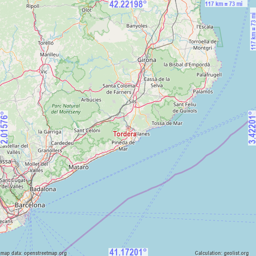
Tordera GPS coordinates[2]
41° 41' 56.904" North, 2° 43' 7.968" East
| Map corner | latitude | longitude |
|---|---|---|
| Upper-left | 42.22198°, | 2.01576° |
| Center: | 41.69914°, | 2.71888° |
| Lower-right: | 41.17201°, | 3.42201° |
| Map W x H: | 116.7×116.7 km | = 72.5×72.5mi |
| max Lat: | 43.74134° ⇑34% North |
| Tordera: | 41.69914° |
| min Lat: | ⇓66% South 27.64134° |
| min Long | Tordera | max Long |
| -18.00367° | 2.71888° | 4.2899° |
| W 97.3%⇐ | ⇒2.7% E |
Elevation
Elevation of Tordera is 41 m = 135 ft, and this is 557 m = 1827 ft below average elevation for this country.
| Max E: |
1682 m = 5518 ft | 92.5% |
| Avg. | 598 m = 1962 ft | |
| Tordera | 41 m = 135 ft | |
Min E: |
0 m = 0 ft | 7.5% |
See also: Spain elevation on elevation.city.
Geographical zone
Tordera is located in North temperate zone (between Tropic of Cancer and the Arctic Circle). Distance of this Northern Tropic circle is 2030.6 km =1261.8 mi to South.| Distance of | km | miles | from Tordera |
|---|---|---|---|
| North Pole | 5370.6 | 3337.1 | to North |
| Arctic Circle | 2764.7 | 1717.9 | to North |
| Tropic Cancer | 2030.6 | 1261.8 | to South |
| Equator | 4636.5 | 2881 | to South |


Nearby cities:
15 places around Tordera: (largest is in red/bold)
• Blanes
6.6 km =4.1 mi,  115°
115°
• Breda
14.3 km =8.9 mi,  292°
292°
• Calella
10.9 km =6.8 mi,  209°
209°
• Hostalric
9.1 km =5.7 mi,  308°
308°
• Lloret de Mar
10.5 km =6.5 mi,  89°
89°
• Malgrat de Mar
6.1 km =3.8 mi,  162°
162°
• Massanes
9.2 km =5.7 mi,  323°
323°
• Maçanet de la Selva
9.4 km =5.8 mi,  7°
7°
• Palafolls
4.4 km =2.7 mi,  144°
144°
• Pineda de Mar
8.3 km =5.2 mi,  197°
197°
• Riudarenes
13.1 km =8.1 mi,  359°
359°
• Sant Pol de Mar
13.7 km =8.5 mi,  217°
217°
• Santa Susanna
7.3 km =4.5 mi,  181°
181°
• Sils
12.3 km =7.6 mi, 10°
• Vidreres
10.8 km =6.7 mi,  29°
29°
Sources, notices
• [Note1] Compared only with cities in Spain existing in our database
• [Src1] Map data: © OpenStreetMap contributors (CC-BY-SA)
• [Src2] Other city data from geonames.org with taken over terms of usage.
• [Src3] Geographical zone / Annual Mean Temperature by Robert A. Rohde @ Wikipedia
