San Cebrián de Castro geodata
San Cebrián de Castro (Castille and León) is a seat of a third-order administrative division; located in Spain in Europe/Madrid (GMT+2) time zone. With population of 326 people, there are 4405 cities with bigger population in this country. Compared to other cities in Spain, 66.2% of cities are located further ↓South; 82.7% of cities are located further →East and 52.8% of cities have lower elevation than San Cebrián de Castro. Note1
Administrative division(s):
- Level 1: Castille and León
- Level 2: Provincia de Zamora
- Level 3: San Cebrián de Castro
Current local time in San Cebrián de Castro:
11:55 PM, ThursdayDifference from your time zone: hours


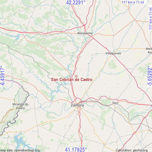
San Cebrián de Castro GPS coordinates[2]
41° 42' 22.752" North, 5° 45' 21.78" West
| Map corner | latitude | longitude |
|---|---|---|
| Upper-left | 42.2291°, | -6.45917° |
| Center: | 41.70632°, | -5.75605° |
| Lower-right: | 41.17925°, | -5.05292° |
| Map W x H: | 116.7×116.7 km | = 72.5×72.5mi |
| max Lat: | 43.74134° ⇑33.8% North |
| San Cebrián de Castro: | 41.70632° |
| min Lat: | ⇓66.2% South 27.64134° |
| min Long | San Cebrián de | max Long |
| -18.00367° | -5.75605° | 4.2899° |
| W 17.3%⇐ | ⇒82.7% E |
Elevation
Elevation of San Cebrián de Castro is 688 m = 2257 ft, and this is 90 m = 295 ft above average elevation for this country.
| Max E: |
1682 m = 5518 ft | 47.2% |
| San Cebrián de Castro | 688 m 2257 ft | |
| Avg. | 598 m = 1962 ft | |
Min E: |
0 m = 0 ft | 52.8% |
See also: Spain elevation on elevation.city.
Geographical zone
San Cebrián de Castro is located in North temperate zone (between Tropic of Cancer and the Arctic Circle). Distance of this Northern Tropic circle is 2031.4 km =1262.3 mi to South.| Distance of | km | miles | from San Cebrián de Castro |
|---|---|---|---|
| North Pole | 5369.8 | 3336.6 | to North |
| Arctic Circle | 2763.9 | 1717.4 | to North |
| Tropic Cancer | 2031.4 | 1262.3 | to South |
| Equator | 4637.3 | 2881.5 | to South |


Nearby cities:
15 places around San Cebrián de Castro: (largest is in red/bold)
• Arquillinos
8.2 km =5.1 mi,  87°
87°
• Aspariegos
13.5 km =8.4 mi,  105°
105°
• Benegiles
13.4 km =8.3 mi,  131°
131°
• Cerecinos del Carrizal
8.9 km =5.5 mi, 106°
• Granja de Moreruela
11.6 km =7.2 mi,  7°
7°
• Manganeses de la Lampreana
6.2 km =3.9 mi,  37°
37°
• Montamarta
7.7 km =4.8 mi,  211°
211°
• Moreruela de Tábara
13.6 km =8.5 mi,  316°
316°
• Moreruela de los Infanzones
9.3 km =5.8 mi,  153°
153°
• Pajares de la Lampreana
5.3 km =3.3 mi,  78°
78°
• Perilla de Castro
10.2 km =6.3 mi,  281°
281°
• Piedrahita de Castro
3.6 km =2.2 mi,  141°
141°
• Santa Eufemia del Barco
12.2 km =7.6 mi,  255°
255°
• Torres del Carrizal
12.2 km =7.6 mi, 144°
• Villalba de la Lampreana
10.4 km =6.5 mi,  66°
66°
Sources, notices
• [Note1] Compared only with cities in Spain existing in our database
• [Src1] Map data: © OpenStreetMap contributors (CC-BY-SA)
• [Src2] Other city data from geonames.org with taken over terms of usage.
• [Src3] Geographical zone / Annual Mean Temperature by Robert A. Rohde @ Wikipedia
