Perilla de Castro geodata
Perilla de Castro (Castille and León) is a seat of a third-order administrative division; located in Spain in Europe/Madrid (GMT+2) time zone. With population of 219 people, there are 4924 cities with bigger population in this country. Compared to other cities in Spain, 66.7% of cities are located further ↓South; 84.3% of cities are located further →East and 57.4% of cities have lower elevation than Perilla de Castro. Note1
Administrative division(s):
- Level 1: Castille and León
- Level 2: Provincia de Zamora
- Level 3: Perilla de Castro


Perilla de Castro GPS coordinates[2]
41° 43' 31.44" North, 5° 52' 34.896" West
| Map corner | latitude | longitude |
|---|---|---|
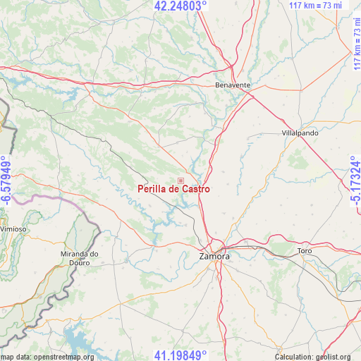
| Upper-left | 42.24803°, | -6.57949° |
| Center: | 41.7254°, | -5.87636° |
| Lower-right: | 41.19849°, | -5.17324° |
| Map W x H: | 116.7×116.7 km | = 72.5×72.5mi |
| max Lat: | 43.74134° ⇑33.3% North |
| Perilla de Castro: | 41.7254° |
| min Lat: | ⇓66.7% South 27.64134° |
| min Long | Perilla de Cast | max Long |
| -18.00367° | -5.87636° | 4.2899° |
| W 15.7%⇐ | ⇒84.3% E |
Elevation
Elevation of Perilla de Castro is 726 m = 2382 ft, and this is 128 m = 420 ft above average elevation for this country.
| Max E: |
1682 m = 5518 ft | 42.6% |
| Perilla de Castro | 726 m 2382 ft | |
| Avg. | 598 m = 1962 ft | |
Min E: |
0 m = 0 ft | 57.4% |
See also: Spain elevation on elevation.city.
Geographical zone
Perilla de Castro is located in North temperate zone (between Tropic of Cancer and the Arctic Circle). Distance of this Northern Tropic circle is 2033.5 km =1263.6 mi to South.| Distance of | km | miles | from Perilla de Castro |
|---|---|---|---|
| North Pole | 5367.6 | 3335.3 | to North |
| Arctic Circle | 2761.7 | 1716 | to North |
| Tropic Cancer | 2033.5 | 1263.6 | to South |
| Equator | 4639.4 | 2882.8 | to South |


Nearby cities:
15 places around Perilla de Castro: (largest is in red/bold)
• Carbajales de Alba
12.8 km =8 mi,  231°
231°
• Faramontanos de Tábara
12.2 km =7.6 mi,  355°
355°
• Granja de Moreruela
14.8 km =9.2 mi,  50°
50°
• Losacio
13.7 km =8.5 mi,  263°
263°
• Manganeses de la Lampreana
14.1 km =8.8 mi,  78°
78°
• Manzanal del Barco
11.6 km =7.2 mi,  210°
210°
• Montamarta
10.6 km =6.6 mi,  145°
145°
• Moreruela de Tábara
7.9 km =4.9 mi,  4°
4°
• Olmillos de Castro
7.6 km =4.7 mi,  275°
275°
• Palacios del Pan
13.7 km =8.5 mi,  180°
180°
• Piedrahita de Castro
13.2 km =8.2 mi,  112°
112°
• Pozuelo de Tábara
6.8 km =4.2 mi,  347°
347°
• San Cebrián de Castro
10.2 km =6.3 mi,  101°
101°
• Santa Eufemia del Barco
5.6 km =3.5 mi,  199°
199°
• Tábara
13.2 km =8.2 mi,  326°
326°
Sources, notices
• [Note1] Compared only with cities in Spain existing in our database
• [Src1] Map data: © OpenStreetMap contributors (CC-BY-SA)
• [Src2] Other city data from geonames.org with taken over terms of usage.
• [Src3] Geographical zone / Annual Mean Temperature by Robert A. Rohde @ Wikipedia
