Ruesga geodata
Ruesga (Castille and León) is a populated place; located in Spain in Europe/Madrid (GMT+2) time zone. With population of 1,120 people, there are 2805 cities with bigger population in this country. Compared to other cities in Spain, 93.2% of cities are located further ↓South; 66.6% of cities are located further →East and 90.7% of cities have lower elevation than Ruesga. Note1
Administrative division(s):
- Level 1: Castille and León
- Level 2: Provincia de Palencia
- Level 3: Cervera de Pisuerga


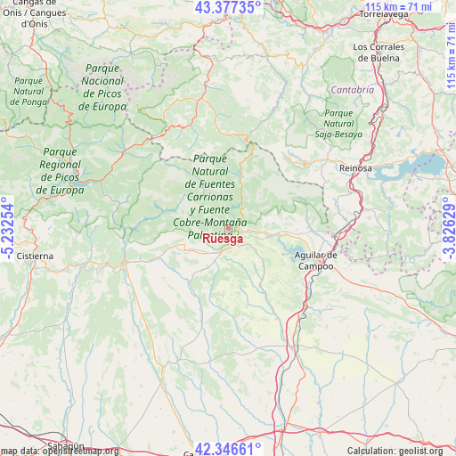
Ruesga GPS coordinates[2]
42° 51' 50.868" North, 4° 31' 45.912" West
| Map corner | latitude | longitude |
|---|---|---|
| Upper-left | 43.37735°, | -5.23254° |
| Center: | 42.86413°, | -4.52942° |
| Lower-right: | 42.34661°, | -3.82629° |
| Map W x H: | 114.6×114.6 km | = 71.2×71.2mi |
| max Lat: | 43.74134° ⇑6.8% North |
| Ruesga: | 42.86413° |
| min Lat: | ⇓93.2% South 27.64134° |
| min Long | Ruesga | max Long |
| -18.00367° | -4.52942° | 4.2899° |
| W 33.4%⇐ | ⇒66.6% E |
Elevation
Elevation of Ruesga is 1044 m = 3425 ft, and this is 446 m = 1463 ft above average elevation for this country.
| Max E: |
1682 m = 5518 ft | 9.3% |
| Ruesga | 1044 m 3425 ft | |
| Avg. | 598 m = 1962 ft | |
Min E: |
0 m = 0 ft | 90.7% |
See also: Spain elevation on elevation.city.
Geographical zone
Ruesga is located in North temperate zone (between Tropic of Cancer and the Arctic Circle). Distance of this Northern Tropic circle is 2160.1 km =1342.2 mi to South.| Distance of | km | miles | from Ruesga |
|---|---|---|---|
| North Pole | 5241 | 3256.6 | to North |
| Arctic Circle | 2635.1 | 1637.4 | to North |
| Tropic Cancer | 2160.1 | 1342.2 | to South |
| Equator | 4766 | 2961.5 | to South |


Nearby cities:
15 places around Ruesga: (largest is in red/bold)
• Brañosera
19.7 km =12.2 mi,  66°
66°
• Castrejón de la Peña
8.4 km =5.2 mi,  222°
222°
• Cervera de Pisuerga
2.6 km =1.6 mi,  83°
83°
• Congosto de Valdavia
18.6 km =11.6 mi,  207°
207°
• Dehesa de Montejo
5.2 km =3.2 mi,  162°
162°
• Micieces de Ojeda
20.1 km =12.5 mi, 163°
• Mudá
11.1 km =6.9 mi, 83°
• Olmos de Ojeda
17.9 km =11.1 mi,  151°
151°
• Payo de Ojeda
16.7 km =10.4 mi,  165°
165°
• Polentinos
8.4 km =5.2 mi,  0°
0°
• Respenda de la Peña
16.8 km =10.4 mi,  229°
229°
• Salinas de Pisuerga
12.4 km =7.7 mi,  97°
97°
• San Cebrián de Mudá
12 km =7.5 mi, 74°
• Santibáñez de la Peña
17.5 km =10.9 mi,  249°
249°
• Triollo
14.1 km =8.8 mi,  298°
298°
Sources, notices
• [Note1] Compared only with cities in Spain existing in our database
• [Src1] Map data: © OpenStreetMap contributors (CC-BY-SA)
• [Src2] Other city data from geonames.org with taken over terms of usage.
• [Src3] Geographical zone / Annual Mean Temperature by Robert A. Rohde @ Wikipedia
