Brañosera geodata
Brañosera (Castille and León) is a seat of a third-order administrative division; located in Spain in Europe/Madrid (GMT+2) time zone. With population of 269 people, there are 4634 cities with bigger population in this country. Compared to other cities in Spain, 93.9% of cities are located further ↓South; 63.9% of cities are located further →East and 97.3% of cities have lower elevation than Brañosera. Note1
Administrative division(s):
- Level 1: Castille and León
- Level 2: Provincia de Palencia
- Level 3: Brañosera


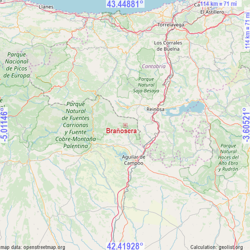
Brañosera GPS coordinates[2]
42° 56' 10.32" North, 4° 18' 29.988" West
| Map corner | latitude | longitude |
|---|---|---|
| Upper-left | 43.44881°, | -5.01146° |
| Center: | 42.9362°, | -4.30833° |
| Lower-right: | 42.41928°, | -3.60521° |
| Map W x H: | 114.5×114.5 km | = 71.1×71.1mi |
| max Lat: | 43.74134° ⇑6.1% North |
| Brañosera: | 42.9362° |
| min Lat: | ⇓93.9% South 27.64134° |
| min Long | Brañosera | max Long |
| -18.00367° | -4.30833° | 4.2899° |
| W 36.1%⇐ | ⇒63.9% E |
Elevation
Elevation of Brañosera is 1218 m = 3996 ft, and this is 620 m = 2034 ft above average elevation for this country.
| Max E: |
1682 m = 5518 ft | 2.7% |
| Brañosera | 1218 m 3996 ft | |
| Avg. | 598 m = 1962 ft | |
Min E: |
0 m = 0 ft | 97.3% |
See also: Spain elevation on elevation.city.
Geographical zone
Brañosera is located in North temperate zone (between Tropic of Cancer and the Arctic Circle). Distance of this Northern Tropic circle is 2168.1 km =1347.2 mi to South.| Distance of | km | miles | from Brañosera |
|---|---|---|---|
| North Pole | 5233 | 3251.6 | to North |
| Arctic Circle | 2627.1 | 1632.4 | to North |
| Tropic Cancer | 2168.1 | 1347.2 | to South |
| Equator | 4774.1 | 2966.5 | to South |


Nearby cities:
15 places around Brañosera: (largest is in red/bold)
• Aguilar de Campoo
16.3 km =10.1 mi,  165°
165°
• Barruelo de Santullán
3.8 km =2.4 mi,  151°
151°
• Cervera de Pisuerga
17.3 km =10.7 mi,  243°
243°
• Dehesa de Montejo
21 km =13 mi,  231°
231°
• Mataporquera
13.7 km =8.5 mi,  119°
119°
• Mudá
9.7 km =6 mi, 225°
• Pesquera
24.7 km =15.3 mi,  48°
48°
• Polentinos
18 km =11.2 mi,  271°
271°
• Pomar de Valdivia
21.3 km =13.2 mi, 147°
• Reinosa
15.5 km =9.6 mi,  63°
63°
• Ruesga
19.7 km =12.2 mi,  246°
246°
• Salinas de Pisuerga
11.1 km =6.9 mi,  210°
210°
• San Cebrián de Mudá
8 km =5 mi, 232°
• Santiurde de Reinosa
23 km =14.3 mi, 52°
• Villaescusa
11.9 km =7.4 mi,  75°
75°
Sources, notices
• [Note1] Compared only with cities in Spain existing in our database
• [Src1] Map data: © OpenStreetMap contributors (CC-BY-SA)
• [Src2] Other city data from geonames.org with taken over terms of usage.
• [Src3] Geographical zone / Annual Mean Temperature by Robert A. Rohde @ Wikipedia
