Revenga de Campos geodata
Revenga de Campos (Castille and León) is a seat of a third-order administrative division; located in Spain in Europe/Madrid (GMT+2) time zone. With population of 179 people, there are 5189 cities with bigger population in this country. Compared to other cities in Spain, 81.4% of cities are located further ↓South; 65.9% of cities are located further →East and 66.3% of cities have lower elevation than Revenga de Campos. Note1
Administrative division(s):
- Level 1: Castille and León
- Level 2: Provincia de Palencia
- Level 3: Revenga de Campos


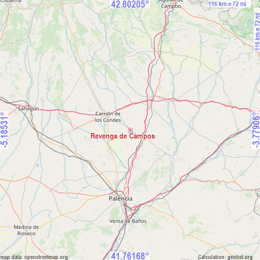
Revenga de Campos GPS coordinates[2]
42° 17' 2.436" North, 4° 28' 55.848" West
| Map corner | latitude | longitude |
|---|---|---|
| Upper-left | 42.80205°, | -5.18531° |
| Center: | 42.28401°, | -4.48218° |
| Lower-right: | 41.76168°, | -3.77906° |
| Map W x H: | 115.7×115.7 km | = 71.9×71.9mi |
| max Lat: | 43.74134° ⇑18.6% North |
| Revenga de Campos: | 42.28401° |
| min Lat: | ⇓81.4% South 27.64134° |
| min Long | Revenga de Camp | max Long |
| -18.00367° | -4.48218° | 4.2899° |
| W 34.1%⇐ | ⇒65.9% E |
Elevation
Elevation of Revenga de Campos is 787 m = 2582 ft, and this is 189 m = 620 ft above average elevation for this country.
| Max E: |
1682 m = 5518 ft | 33.7% |
| Revenga de Campos | 787 m 2582 ft | |
| Avg. | 598 m = 1962 ft | |
Min E: |
0 m = 0 ft | 66.3% |
See also: Spain elevation on elevation.city.
Geographical zone
Revenga de Campos is located in North temperate zone (between Tropic of Cancer and the Arctic Circle). Distance of this Northern Tropic circle is 2095.6 km =1302.1 mi to South.| Distance of | km | miles | from Revenga de Campos |
|---|---|---|---|
| North Pole | 5305.5 | 3296.7 | to North |
| Arctic Circle | 2699.6 | 1677.5 | to North |
| Tropic Cancer | 2095.6 | 1302.1 | to South |
| Equator | 4701.5 | 2921.4 | to South |


Nearby cities:
15 places around Revenga de Campos: (largest is in red/bold)
• Amayuelas de Arriba
8.1 km =5 mi,  183°
183°
• Arconada
5 km =3.1 mi,  346°
346°
• Boadilla del Camino
11.6 km =7.2 mi,  103°
103°
• Frómista
6.6 km =4.1 mi,  106°
106°
• Lomas
5.8 km =3.6 mi,  258°
258°
• Manquillos
11.3 km =7 mi,  218°
218°
• Marcilla de Campos
8 km =5 mi,  61°
61°
• Piña de Campos
8.7 km =5.4 mi,  154°
154°
• Población de Campos
3.3 km =2.1 mi,  118°
118°
• San Cebrián de Campos
10.1 km =6.3 mi,  203°
203°
• San Mamés de Campos
10.5 km =6.5 mi,  319°
319°
• Villalcázar de Sirga
6.2 km =3.9 mi,  306°
306°
• Villarmentero de Campos
2.1 km =1.3 mi, 316°
• Villoldo
10.2 km =6.3 mi,  246°
246°
• Villovieco
1.2 km =0.7 mi,  3°
3°
Sources, notices
• [Note1] Compared only with cities in Spain existing in our database
• [Src1] Map data: © OpenStreetMap contributors (CC-BY-SA)
• [Src2] Other city data from geonames.org with taken over terms of usage.
• [Src3] Geographical zone / Annual Mean Temperature by Robert A. Rohde @ Wikipedia
