Lomas geodata
Lomas (Castille and León) is a seat of a third-order administrative division; located in Spain in Europe/Madrid (GMT+2) time zone. With population of 54 people, there are 6416 cities with bigger population in this country. Compared to other cities in Spain, 81.2% of cities are located further ↓South; 66.8% of cities are located further →East and 71.3% of cities have lower elevation than Lomas. Note1
Administrative division(s):
- Level 1: Castille and León
- Level 2: Provincia de Palencia
- Level 3: Lomas


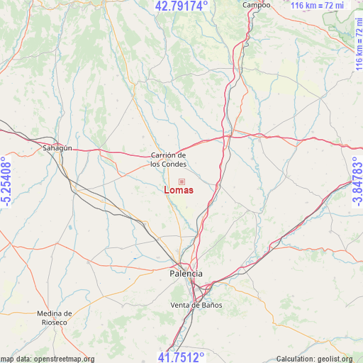
Lomas GPS coordinates[2]
42° 16' 25.032" North, 4° 33' 3.42" West
| Map corner | latitude | longitude |
|---|---|---|
| Upper-left | 42.79174°, | -5.25408° |
| Center: | 42.27362°, | -4.55095° |
| Lower-right: | 41.7512°, | -3.84783° |
| Map W x H: | 115.7×115.7 km | = 71.9×71.9mi |
| max Lat: | 43.74134° ⇑18.8% North |
| Lomas: | 42.27362° |
| min Lat: | ⇓81.2% South 27.64134° |
| min Long | Lomas | max Long |
| -18.00367° | -4.55095° | 4.2899° |
| W 33.2%⇐ | ⇒66.8% E |
Elevation
Elevation of Lomas is 823 m = 2700 ft, and this is 225 m = 738 ft above average elevation for this country.
| Max E: |
1682 m = 5518 ft | 28.7% |
| Lomas | 823 m 2700 ft | |
| Avg. | 598 m = 1962 ft | |
Min E: |
0 m = 0 ft | 71.3% |
See also: Spain elevation on elevation.city.
Geographical zone
Lomas is located in North temperate zone (between Tropic of Cancer and the Arctic Circle). Distance of this Northern Tropic circle is 2094.5 km =1301.5 mi to South.| Distance of | km | miles | from Lomas |
|---|---|---|---|
| North Pole | 5306.7 | 3297.4 | to North |
| Arctic Circle | 2700.8 | 1678.2 | to North |
| Tropic Cancer | 2094.5 | 1301.5 | to South |
| Equator | 4700.4 | 2920.7 | to South |


Nearby cities:
15 places around Lomas: (largest is in red/bold)
• Amayuelas de Arriba
8.6 km =5.3 mi,  143°
143°
• Arconada
7.5 km =4.7 mi,  36°
36°
• Calzada de los Molinos
10.3 km =6.4 mi,  305°
305°
• Carrión de los Condes
8.6 km =5.3 mi,  331°
331°
• Manquillos
7.7 km =4.8 mi,  190°
190°
• Perales
9.2 km =5.7 mi,  195°
195°
• Población de Campos
8.5 km =5.3 mi,  92°
92°
• Revenga de Campos
5.8 km =3.6 mi,  78°
78°
• San Cebrián de Campos
8.3 km =5.2 mi,  168°
168°
• San Mamés de Campos
9.1 km =5.7 mi,  352°
352°
• Villalcázar de Sirga
4.8 km =3 mi,  7°
7°
• Villamuera de la Cueza
11.5 km =7.1 mi,  261°
261°
• Villarmentero de Campos
5 km =3.1 mi,  57°
57°
• Villoldo
4.7 km =2.9 mi,  232°
232°
• Villovieco
6.2 km =3.9 mi,  67°
67°
Sources, notices
• [Note1] Compared only with cities in Spain existing in our database
• [Src1] Map data: © OpenStreetMap contributors (CC-BY-SA)
• [Src2] Other city data from geonames.org with taken over terms of usage.
• [Src3] Geographical zone / Annual Mean Temperature by Robert A. Rohde @ Wikipedia
