Piña de Esgueva geodata
Piña de Esgueva (Castille and León) is a seat of a third-order administrative division; located in Spain in Europe/Madrid (GMT+2) time zone. With population of 349 people, there are 4317 cities with bigger population in this country. Compared to other cities in Spain, 66.8% of cities are located further ↓South; 65.2% of cities are located further →East and 60.5% of cities have lower elevation than Piña de Esgueva. Note1
Administrative division(s):
- Level 1: Castille and León
- Level 2: Provincia de Valladolid
- Level 3: Piña de Esgueva


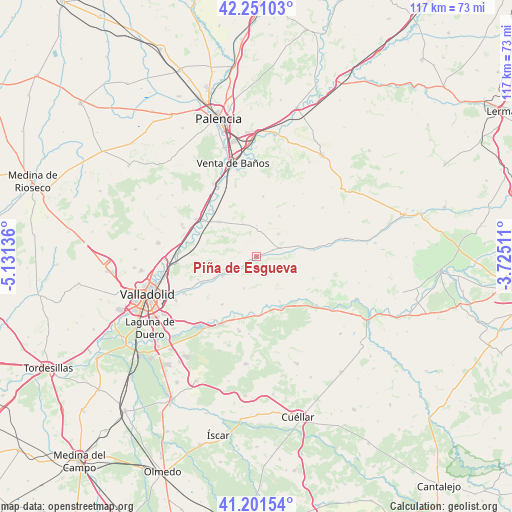
Piña de Esgueva GPS coordinates[2]
41° 43' 42.348" North, 4° 25' 41.628" West
| Map corner | latitude | longitude |
|---|---|---|
| Upper-left | 42.25103°, | -5.13136° |
| Center: | 41.72843°, | -4.42823° |
| Lower-right: | 41.20154°, | -3.72511° |
| Map W x H: | 116.7×116.7 km | = 72.5×72.5mi |
| max Lat: | 43.74134° ⇑33.2% North |
| Piña de Esgueva: | 41.72843° |
| min Lat: | ⇓66.8% South 27.64134° |
| min Long | Piña de Esguev | max Long |
| -18.00367° | -4.42823° | 4.2899° |
| W 34.8%⇐ | ⇒65.2% E |
Elevation
Elevation of Piña de Esgueva is 748 m = 2454 ft, and this is 150 m = 492 ft above average elevation for this country.
| Max E: |
1682 m = 5518 ft | 39.5% |
| Piña de Esgueva | 748 m 2454 ft | |
| Avg. | 598 m = 1962 ft | |
Min E: |
0 m = 0 ft | 60.5% |
See also: Spain elevation on elevation.city.
Geographical zone
Piña de Esgueva is located in North temperate zone (between Tropic of Cancer and the Arctic Circle). Distance of this Northern Tropic circle is 2033.8 km =1263.7 mi to South.| Distance of | km | miles | from Piña de Esgueva |
|---|---|---|---|
| North Pole | 5367.3 | 3335.1 | to North |
| Arctic Circle | 2761.4 | 1715.9 | to North |
| Tropic Cancer | 2033.8 | 1263.7 | to South |
| Equator | 4639.8 | 2883 | to South |


Nearby cities:
15 places around Piña de Esgueva: (largest is in red/bold)
• Alba de Cerrato
10.8 km =6.7 mi,  29°
29°
• Amusquillo
10.8 km =6.7 mi,  78°
78°
• Castrillo-Tejeriego
5.5 km =3.4 mi,  120°
120°
• Cubillas de Cerrato
8.4 km =5.2 mi,  337°
337°
• Esguevillas de Esgueva
4.6 km =2.9 mi,  58°
58°
• Olivares de Duero
11.4 km =7.1 mi,  152°
152°
• Olmos de Esgueva
9 km =5.6 mi,  240°
240°
• Población de Cerrato
7.2 km =4.5 mi,  359°
359°
• Quintanilla de Onésimo
12.7 km =7.9 mi, 154°
• San Martín de Valvení
11.9 km =7.4 mi,  283°
283°
• Valoria la Buena
11.6 km =7.2 mi,  313°
313°
• Villaco
13.3 km =8.3 mi, 84°
• Villafuerte
8.7 km =5.4 mi,  85°
85°
• Villarmentero de Esgueva
10.9 km =6.8 mi, 243°
• Villavaquerín
7.8 km =4.8 mi,  201°
201°
Sources, notices
• [Note1] Compared only with cities in Spain existing in our database
• [Src1] Map data: © OpenStreetMap contributors (CC-BY-SA)
• [Src2] Other city data from geonames.org with taken over terms of usage.
• [Src3] Geographical zone / Annual Mean Temperature by Robert A. Rohde @ Wikipedia
